The best cycling routes around Saint Johns Point
5.0
(1)
33
riders
7
rides
Touring cycling around Saint Johns Point, located at the southern tip of the Lecale peninsula in County Down, Northern Ireland, offers routes primarily along the Irish Sea coastline. The area is characterized by coastal scenery, with views of Dundrum Bay and Killough Harbour. Cyclists can also find routes that provide access to the nearby Strangford Lough, an area of outstanding natural beauty. The terrain is generally moderate, featuring mostly paved surfaces with varying elevation gains.
Best touring cycling routes around…
Last updated: November 15, 2026
2
riders
62.2km
03:51
360m
360m
Embark on the St John's Point Lighthouse loop from Newcastle for a moderate touring cycling experience across the scenic Lecale Peninsula. This route covers 38.7 miles (62.2 km) with an…
4
riders
51.7km
03:05
340m
340m
Embark on the Delamont to Ardglass Harbour loop, a moderate touring bicycle route spanning 32.1 miles (51.7 km). You will experience a rewarding ride with 1112 feet (339 metres) of…

1
riders
62.8km
03:46
440m
440m
Embark on the Saint John's Point loop from Downpatrick, a moderate touring bicycle route spanning 39.0 miles (62.8 km) with an elevation gain of 1460 feet (445 metres). This journey,…
36.3km
02:07
200m
200m
Embark on the Tyrella Beach to Annadorn Dolmen loop for a moderate touring cycling experience that blends coastal beauty with ancient history. This route spans 22.6 miles (36.3 km) with…
8
riders
42.7km
02:33
270m
270m
Moderate bike ride. Good fitness required. Mostly paved surfaces.
Get access to more routes and recommendations from other explorers.
Already have an account?
Our route recommendations are based on thousands of hikes, rides, and runs completed by other people on komoot.
Start today with a free account
Your next adventure awaits.
Popular around Saint Johns Point
Tips from the Community

The vast coastline stretches out endlessly before you, and the panorama with the majestic Mourne Hills in the background creates a scene that is hard to put into words. The gentle waves touching the sand and the silence of the surroundings make you feel the vastness and freedom of this place.
1
0
This impressive stone circle, dating from the late Neolithic to early Bronze Age, consists of over 50 upright stones enclosing a diameter of around 35 metres. Access is via a narrow hedge-lined path that takes you directly to the entrance of the circle
1
0
This historic 12th century building is a typical example of an Anglo-Norman motte with a kidney-shaped bailey. The 7.6m high mound, which once housed a wooden tower, was later replaced by a stone tower house, the ruins of which can still be seen today. Access is via Clough's main road; there is a small car park, but it is not always well signposted. Access is usually permitted. The surrounding countryside, with views of the Mourne Mountains, offers a tranquil atmosphere that invites you to linger.
1
0
This picturesque spot is located between Dundrum Bay and Murlough Bay and offers impressive views of the surrounding countryside. The paths there lead through the Murlough National Nature Reserve, a 6,000-year-old dune system that is great for cycling. However, some sections can become slippery in wet weather, so care must be taken. A particular highlight is the Downshire Bridge, which connects the village of Dundrum with the nature reserve and provides a charming crossing over the bay.
1
0

Found on the beautiful peninsula between Dundrum Bay and Murlough Bay (Irish: Murlach, meaning 'sea inlet') Keel Point has perfect views of Slieve Donard, the highest peak in the Kingdom of the Mourne Mountains.
1
0
Extremely atmospheric graveyard with three ruined churches standing in the large graveyard overlooking the lake. The earliest recorded reference is to a parish church here in 1302, with the middle Church being the oldest, probably of the 13th century. The MacCartans had one of their chief seats near the lake and this was probably their principal burial ground.
0
0
The motte and bailey dates to c.1200 and is an excellent example of an Anglo-Norman earthwork castle. The taller mound, the motte, was built of earth to provide a look-out position and the central defence. Excavations at the top of the motte during the 1950s uncovered a wooden palisade which originally extended around the summit. When you climb the motte you realise what an important position the castle is in, over looking the routes east to Downpatrick, south to Dundrum and north to Belfast Lough. The views from the top of the motte west to Slieve Croob are particularly fine.
1
0
One of the best kept Circles I know of. The late Neolithic to earlier Bronze Age monument was excavated in 1937–1939 but its development and date are still not entirely clear. Excavation uncovered a slab feature with three compartments at the west end of the cairn, which could suggest the court tomb tradition, and a single stone cist at the east end which could point to the passage tomb tradition. Cremated remains representing at least seven individuals and some Neolithic pottery were found. Parallels for the outer stone circle with sites in Cumbria have been suggested.
1
0
Frequently Asked Questions
How many touring cycling routes are available around Saint Johns Point?
There are 7 touring cycling routes available around Saint Johns Point. All of these routes are rated as moderate, offering a good balance for various fitness levels.
What kind of terrain can I expect on touring cycling routes around Saint Johns Point?
The touring cycling routes around Saint Johns Point primarily feature coastal scenery with views of the Irish Sea, Dundrum Bay, and Killough Harbour. The terrain is generally moderate, consisting mostly of paved surfaces with varying elevation gains.
Are there any circular touring cycling routes in Saint Johns Point?
Yes, all the touring cycling routes around Saint Johns Point are designed as loops. For example, you can explore the St John's Point Lighthouse loop from Newcastle or the Delamont to Ardglass Harbour loop, both offering scenic circular journeys.
What are some notable landmarks or natural features I can see while cycling around Saint Johns Point?
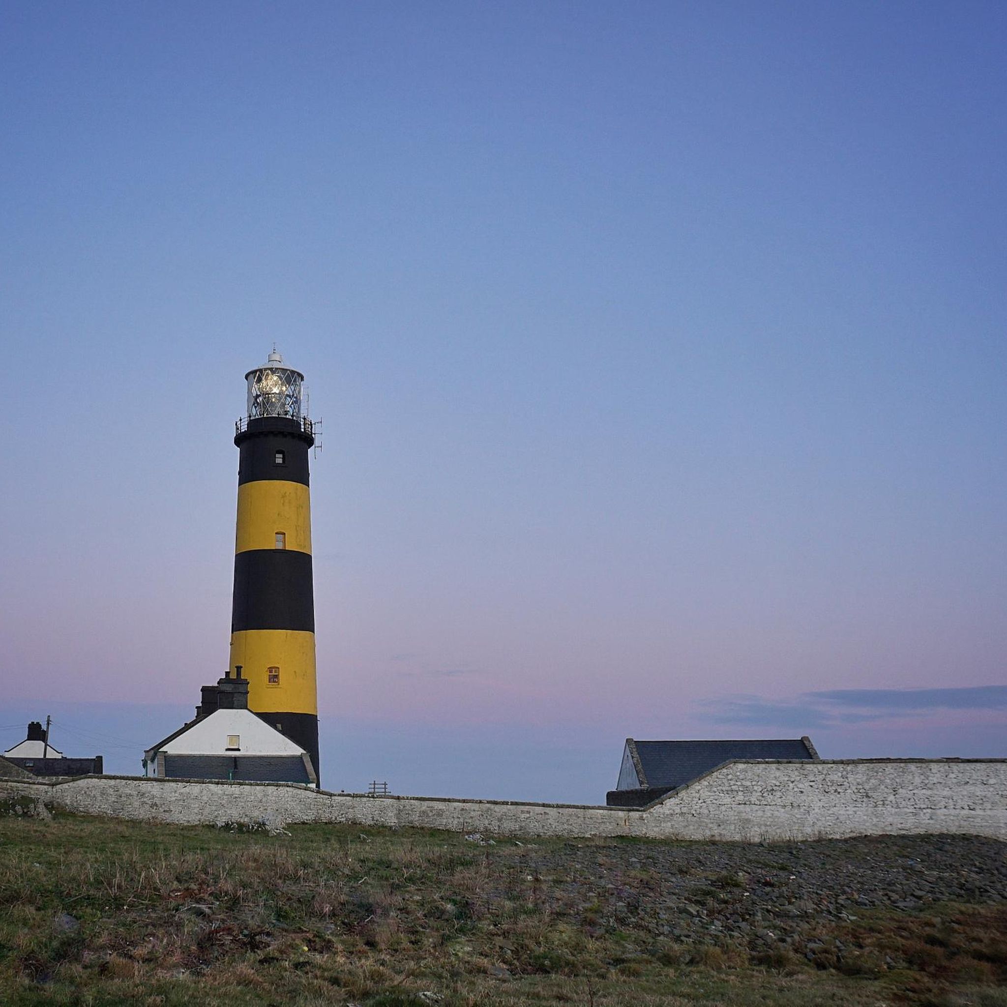
While cycling around Saint Johns Point, you can encounter several interesting landmarks and natural features. The prominent St. John's Point Lighthouse (County Down), known for its vibrant yellow and black bands, is a key attraction. Routes also offer views of Ardglass Harbour, and the area is close to Strangford Lough, an Area of Outstanding Natural Beauty. You might also pass by the ancient Ballynoe Stone Circle.
What do other touring cyclists enjoy most about cycling in Saint Johns Point?
The touring cycling routes in Saint Johns Point are highly rated by the komoot community, with an average score of 5.0 stars. Cyclists often praise the stunning coastal views, the proximity to natural beauty spots like Strangford Lough, and the well-maintained, mostly paved surfaces that make for enjoyable rides.
Are there any family-friendly touring cycling routes in Saint Johns Point?
While all routes are currently rated as moderate, making them suitable for cyclists with some experience, the mostly paved surfaces and scenic coastal paths can be enjoyable for families with older children who are comfortable with longer distances. The Tyrella Beach to Annadorn Dolmen loop is one of the shorter moderate options at 36.3 km.
Can I bring my dog on the touring cycling routes around Saint Johns Point?
Many of the touring cycling routes around Saint Johns Point follow public roads and paths where dogs are generally permitted, especially if kept on a leash. However, it's always advisable to check local regulations for specific areas, particularly around nature reserves or beaches, to ensure a dog-friendly experience.
What is the typical distance and duration for touring cycling routes in this area?
The touring cycling routes around Saint Johns Point vary in length, generally ranging from approximately 36 km to 63 km. Depending on the route, you can expect durations from around 2 hours to just under 4 hours, assuming a moderate cycling pace. For instance, the St John's Point Lighthouse loop from Newcastle is 62.2 km and takes about 3 hours 51 minutes.
Are there places to explore near the cycling routes, such as beaches or viewpoints?
Absolutely! The area offers several scenic spots. You can enjoy views of the Mourne Mountains from Strangford & Lecale Beach, or visit Ballyhornan Beach. The coastal nature of the routes means you'll frequently encounter beautiful sea views and opportunities to stop and enjoy the scenery.
Is there accommodation available near Saint Johns Point for cyclists?
Yes, the area around Saint Johns Point in County Down offers various accommodation options. Notably, the lightkeepers' cottages at St. John's Point Lighthouse itself provide unique self-catering stays. Additionally, nearby towns and villages will have guesthouses, B&Bs, and hotels suitable for cyclists.
What is the best time of year to go touring cycling around Saint Johns Point?
The best time for touring cycling around Saint Johns Point is generally during the spring, summer, and early autumn months (April to October). During these periods, the weather is typically milder, with longer daylight hours, making for more pleasant cycling conditions and better visibility of the coastal landscapes.
Are there any cafes or pubs along the touring cycling routes for refreshments?
While specific cafes or pubs directly on every route segment might be limited due to the remote nature of some coastal sections, the routes often pass through or near villages and towns where you can find establishments for refreshments. Planning your route with potential stops in mind is recommended.
Most popular routes around Saint Johns Point
Most popular attractions around Saint Johns Point

Get inspired with the komoot mobile app


Explore more
Browse the best Cycling routes in other regions.
