The best road cycling routes around Portovenere
4.3
(527)
9,430
riders
96
rides
Road cycling around Portovenere features a varied landscape characterized by its coastal position along the Ligurian Sea and the rugged terrain of the surrounding hills. The region includes a mix of challenging climbs and scenic routes offering views of the Gulf of La Spezia and nearby villages. Road cyclists can expect winding roads that traverse both elevated sections and coastal stretches.
Best road cycling routes around Portovenere
- The most popular road cycling route is Riomaggiore and Manarola from La Spezia…
Last updated: October 18, 2026
4.6
(26)
524
riders
51.0km
03:08
1,430m
1,430m
This difficult racebike loop, "Riomaggiore and Manarola from La Spezia with return via Pignone – loop tour," takes you through the stunning Ligurian landscape, connecting two famous Cinque Terre villages.…
4.9
(27)
648
riders
74.4km
04:54
2,230m
2,230m
Hard road ride. Very good fitness required. Mostly well-paved surfaces and easy to ride.

4.4
(44)
309
riders
28.9km
01:28
420m
420m
Moderate road ride. Good fitness required. Mostly well-paved surfaces and easy to ride.
4.5
(8)
178
riders
37.9km
02:18
980m
980m
Hard road ride. Very good fitness required. Mostly well-paved surfaces and easy to ride.
3.3
(10)
159
riders
54.4km
02:26
540m
540m
Moderate road ride. Good fitness required. Mostly well-paved surfaces and easy to ride.
Get access to more routes and recommendations from other explorers.
Already have an account?
Our route recommendations are based on thousands of hikes, rides, and runs completed by other people on komoot.
Start today with a free account
Your next adventure awaits.



Tips from the Community

The main scenic coastal road in the Cinque Terre National Park is the Strada Provinciale 370 (SP 370), historically known as Litoranea delle Cinque Terre. Road Characteristics (SP 370) Route: Connects the town of La Spezia with the Chiesanuova area and the villages at altitude. Views: It runs along the mid-slope and at altitude, offering a spectacular sheer view of the sea and the terraced vineyards. Mobility: It is a road with little traffic compared to the low coast, ideal for travelling by car, motorcycle or bicycle. It has several lay-bys to admire the landscape
0
0
The city is located at the extreme east of the Liguria region, a few kilometers from the border with Tuscany, in the center of a deep natural gulf to which it gives its name. The gulf, also known as the Gulf of Poets for its beauty, is encircled by a continuous chain of heights whose highest peaks, Monte Verrugoli (749 m above sea level), Monte Parodi (673 m above sea level), Monte Santa Croce (543 m above sea level), and Monte Viseggi (347 m above sea level), located on the western side of the inhabited center, overlook the city of La Spezia. The municipal territory of Spezia is part of the interregional Magra river basin authority, while a small portion of the municipal territory, consisting of the small village of Tramonti and the surrounding hill, falls within the Cinque Terre National Park.
0
0
The various hamlets and villages that make up the municipality of Pignone are located in the valleys of the Pignone stream (a right tributary of the Vara river) and its tributary Casale, both minor valleys of the middle and lower Val di Vara. The territory is part of the Montemarcello-Magra-Vara Regional Natural Park.
0
0
The panoramic view of the gulf and the port of La Spezia opens up as you climb along the coastal road that leads from La Spezia to Riomaggiore and the Cinque Terre (SP370, the so-called "Litoranea" road).
0
0
The main panoramic coastal road in the Cinque Terre National Park is the Strada statale 370 Litoranea delle Cinque Terre, which connects La Spezia to Chiesanuova at altitude.
0
0
The Doria Castle is a fortress located on the rocky hill overlooking the fishing village of Portovenere, in the province of La Spezia. Considered one of the most majestic military architectures of the Republic of Genoa in the Ligurian Levante, it is reached by taking the road to the Castle.
0
0
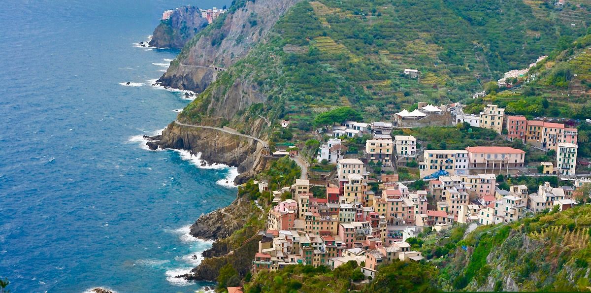
The Cinque Terre are ancient fishing villages located along the rugged Italian coast. Each of these villages is characterized by colorful houses and vineyards clinging to the steep terraces carved into the coast. The harbors are crowded with fishing boats, and in the typical trattorias, you can try seafood specialties, as well as the famous Ligurian condiment: pesto. The Sentiero Azzurro, a hiking trail that runs along the coast, connects the Cinque Terre and offers splendid sea views.
0
0
The Castle of Lerici is a polygonal fortification that stands in a dominant position on the rocky promontory of the Lerici cove, in the province of La Spezia.
0
0
Frequently Asked Questions
How many road cycling routes are available around Portovenere?
There are over 90 road cycling routes around Portovenere, offering a diverse range of options for different skill levels and preferences.
Are there easy road cycling routes suitable for beginners in Portovenere?
Yes, Portovenere offers 12 easy road cycling routes. These routes are generally shorter and have less elevation gain, making them ideal for those new to road cycling or looking for a relaxed ride.
What are some challenging road cycling routes for experienced riders?
For experienced riders, Portovenere has 34 difficult road cycling routes. One notable challenging route is the Riomaggiore and Manarola from La Spezia with return via Pignone – loop tour, which covers 31.6 miles (51.0 km) with significant elevation changes.
Are there any circular road cycling routes around Portovenere?
Yes, many routes in the Portovenere area are designed as loops. For example, the View of Portovenere Bay – View of the naval base loop from La Spezia Centrale offers a moderate 17.9 miles (28.9 km) circular path with scenic views.
What is the best season for road biking in Portovenere?
The best seasons for road biking in Portovenere are typically spring (April to June) and autumn (September to October). During these months, the weather is generally mild, and the coastal roads are less crowded than in peak summer. Summers can be very hot, especially for routes with significant climbs.
What kind of scenic viewpoints can I expect along the road cycling routes?
Road cycling routes around Portovenere offer numerous scenic viewpoints. You can expect breathtaking vistas of the Ligurian Sea, the Gulf of La Spezia, and the picturesque coastal villages. Highlights include the Panoramic view over Porto Venere and the Ligurian Coast and views towards the Cinque Terre villages like Manarola and Corniglia.
Are there road cycling routes that pass through villages or offer places to stop for refreshments?
Many routes in the Portovenere region pass through charming villages where you can find cafes and restaurants. The Montemarcello Village – View of Lerici and the Gulf of La Spezia loop from La Spezia Centrale, for instance, takes you through Montemarcello Village, providing opportunities for a break.
What are some notable landmarks or attractions near the road cycling routes?
Beyond the stunning natural scenery, you can find historical and cultural landmarks. The Church of San Pietro (Porto Venere) is a prominent religious site, and you can also find various viewpoints like the View of Porto Venere and the island of Palmaria from Forte del Muzzerone.
What is the typical distance for road cycling routes in Portovenere?
The distances for road cycling routes around Portovenere vary significantly. You can find shorter routes around 18 miles (29 km), such as the View of Portovenere Bay – View of the naval base loop from La Spezia Centrale, up to longer rides exceeding 34 miles (55 km), like the Montemarcello Village – View of Lerici and the Gulf of La Spezia loop from La Spezia Centrale.
What do other road cyclists enjoy most about road cycling in Portovenere?
The area is highly rated by the komoot community, with an average score of 4.4 stars from over 400 reviews. Road cyclists often praise the combination of challenging climbs, rewarding coastal views, and the opportunity to explore historic villages along the routes.
Is public transport accessible for reaching road cycling trailheads in Portovenere?
Many road cycling routes in the Portovenere area, particularly those starting from La Spezia Centrale, are accessible via public transport. La Spezia is a major transport hub, making it convenient to reach starting points by train or bus before beginning your ride.
Are there any routes with views of the Gulf of La Spezia?
Absolutely. The region is renowned for its panoramic views of the Gulf of La Spezia. Routes like the View of the Gulf of La Spezia – Steady climb with view on La Spezia loop from La Spezia Centrale are specifically designed to showcase these stunning vistas.
Most popular attractions around Portovenere

Get inspired with the komoot mobile app


Explore more
Browse the best Road cycling routes in other regions.
