Top 20 Natural Monuments around Hattstedtermarsch
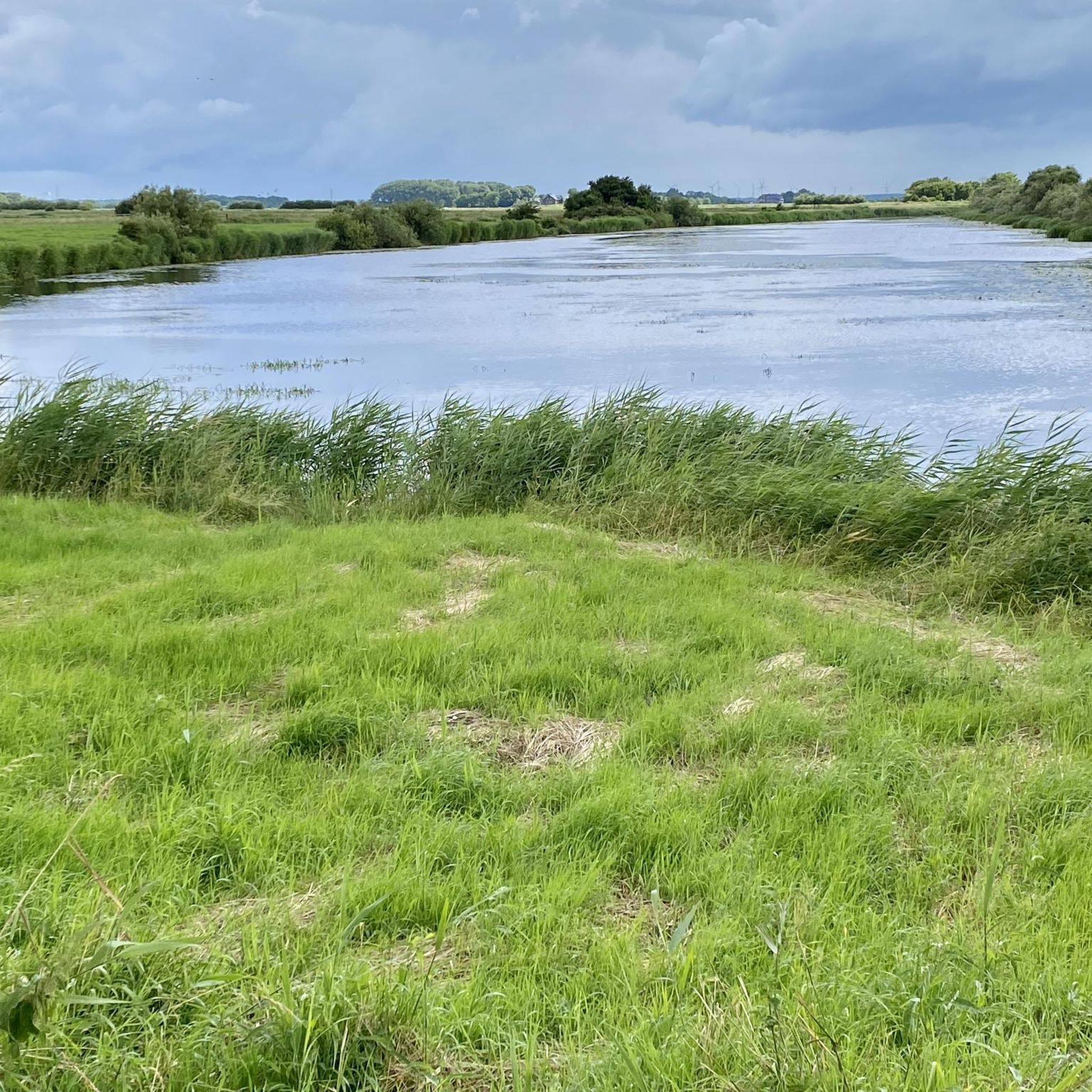
Best natural monuments around Hattstedtermarsch are characterized by the vast, open North Sea landscape and its significant ecological importance. The region offers a unique natural experience, featuring extensive wetlands and diverse habitats. It is located in close proximity to the UNESCO World Heritage Wadden Sea, a globally important ecosystem shaped by tides. Visitors can explore dikes, salt marshes, and various viewpoints offering vistas of the Wadden Sea and the Halligen.
Best natural monuments around Hattstedtermarsch
- The most popular natural monuments is View of the salt marshes and dike at Simonsberg (Wadden Sea National Park), a viewpoint that offers views of the Wadden Sea and salt marshes. From this dike, visitors can observe grazing sheep and the transition between sea and land.
- Another must-see spot is Lüttmoorsiel Seawall and View over the Beltringharder Koog, a viewpoint. This location provides views of the sea, Halligen, and the Beltringharder Koog, with opportunities to observe various sea wading birds.
- Visitors also love Fuhlehörn Beach, a beach. It is one of the few sandy beaches on Nordstrand, offering a place to relax and serving as a starting point for mudflat walks.
- Hattstedtermarsch is known for its viewpoints, beaches, and nature reserves. The area provides a variety of natural monuments to see and explore, including wetlands, coastal features, and protected ecosystems.
- The natural monuments around Hattstedtermarsch are appreciated by the komoot community, with more than 1100 upvotes and over 220 photos shared by visitors.
Last updated: June 25, 2026
Lüttmoorsiel Seawall and View over the Beltringharder Koog
Highlight • Viewpoint
You also see many sheep. The salty grass they eat makes their meats tastier.
Translated by Google •
Tip by

Fuhlehörn Beach
Highlight • Beach
Translated by Google •
Tip by

Sign up now to discover places like this
Get recommendations on the best single tracks, peaks, & plenty of other exciting outdoor places.
Sign up for free
Beltringharder Koog Nature Reserve
Highlight • Natural Monument
Translated by Google •
Tip by

Wester-Spätinge Nature Reserve
Highlight • Natural Monument
the current outer dike was built in 1579 to protect against storm surges and land reclamation.
The dike builders needed large quantities of clay for this. This loamy soil was taken from the area of the Wester sparrows. This laborious manual work was called "spading". The word gave the area its name.
Inland dyke created flat ponds, which today are both natural and cultural monuments. While the surrounding lands were being cleared, the 27-hectare Wester-Spätinge was largely left to its own devices.
Only after the storm surge of 1962 were bigger ones needed due to a dyke breach
lots of cling. The three meter deep excavator hole in the north of the area is now the deepest pond in the nature reserve.
schleswig-holstein.nabu.de/imperia/md/content/schleswigholstein/schutzgebieten/nabu_flyer_nsg_westersp__tinge_6-seiter_100x210_2020-11-10.pdf
Translated by Google •
Tip by

Hamburger Hallig Causeway
Highlight (Segment) • Trail
Translated by Google •
Tip by

Sign up for free to discover even more natural monuments around Hattstedtermarsch.
Sign up for free
Already have an account?
Start today with a free account
Your next adventure awaits.
Login or Signup



Tips from the Community

The Beltringharder Koog is the largest nature reserve on the mainland of Schleswig-Holstein and covers around 3,350 hectares. It is located near the Nordstrand Bay and was dammed in 1987 as part of a coastal protection project. Originally designed as a retention area for floods, the Koog has developed into an important habitat for many bird species and is now a true paradise for nature lovers and ornithologists. The diverse landscape of the Beltringharder Koog includes saltwater lagoons, wet meadows and wilderness areas. These different biotopes provide an ideal habitat for numerous plant and animal species. Countless waders and water birds can be observed here, especially during the migration periods in spring and autumn. There are numerous ways for visitors to explore the Beltringharder Koog. Well-developed walking and hiking trails lead through the area and provide impressive views of nature. There are also bird watching huts that offer an undisturbed view of the wildlife. The West Coast Integrated Station also offers informative exhibitions and guided tours that provide deeper insights into nature conservation and the ecology of the region. The Beltringharder Koog is an outstanding example of successful coastal and nature conservation in Germany. It not only offers valuable protection from storm surges, but also an important refuge for endangered animal and plant species. For nature lovers and bird watchers, the Koog is a worthwhile destination that offers unique nature experiences.
0
0

The 5km out to Hamburger Hallig are well worth it. The concrete slabs are well grouted and are definitely suitable for racing bikes. At the end is the Hallig-Krog restaurant - highly recommended. In the season it fills up quickly after opening.
5
0

The Hamburger Hallig is a non-dyked peninsula on the west coast of the Nordfriesland district in Schleswig-Holstein. The name of the Hallig is reminiscent of two Hamburg merchants, the brothers Rudolf and Arnold Amsinck. In 1624 they acquired the dyke rights on the northeast corner of the island of Strand as Oktroy and built dykes by 1628. This is how the Amsinck-Koog was created. The dikes were destroyed by the Burchardi flood in 1634. Only the terp with the “Hamburger Haus” remained and became a salvation for numerous Strand residents during the storm surge. After 1634, the dikes were rebuilt at great expense and survivors of the flood settled. In 1658 Arnold Amsinck died in the “Hamburger Haus” in his Koog after he had invested his entire fortune in rebuilding the dykes. In 1661 the house was demolished and replaced by a smaller one. What happened was described in literature by the Husum writer Albert Petersen in his novel Arnold Amsinck (1921). In 1711 the dikes were so destroyed that the Amsinck-Koog was a Hallig again. It remained in the possession of the Amsinck family until 1760. The name “Hamburger Hallig” was first mentioned in 1781. The house on the Hallig was destroyed by the February flood of 1825. In 1855 a dam connecting the island to the mainland was planned. The dam was built in 1859/60, but broke again in 1860. In 1866/67 a bush dam was built from Bordelumersiel to Hallig. This dam was fortified in 1874 and added a spillway that was closed in 1875. Due to the interruption of the tidal flows, the silt formation on both sides of the dam was greatly accelerated. The experience gained here has had a decisive influence on the further development of land reclamation. In 1878 the tax authorities bought the Hallig and from then on leased it for management. In 1880 an artesian well was built. The dam has been navigable since 1901. In 1908 the Hallig was 96 hectares in size. On April 16, 1930, it was 216 hectares in size including the dyke foreland and was declared a nature reserve. The Hamburger Hallig is no longer an island since it was connected to the mainland by a causeway in 1860. While a land connection via a dam does not, by definition, turn an island into a peninsula, the salt marshes in front of the dam are added here. https://de.wikipedia.org/wiki/Hamburger_Hallig
5
1

beautiful view of the Wadden Sea
4
2

The wide view is indescribably beautiful!
7
4

Island feeling on the mainland.
3
2

From this dike, you reach infinite horizons. You have views of the sea, but also of the halligens and the Beltringharder Koog. As you evolve near mudflats, many sea wading birds better known as wading birds are visible. Oystercatchers, curlews, sandpipers, sandpipers. All these birds find their pantries in the mud. You also see many sheep. The salty grass they eat makes their meats tastier.
5
2

Great piece out into the Watt. Not quite as ideal for the road bike. Always busy.
10
2
Frequently Asked Questions
What unique natural features define the Hattstedtermarsch region?
The Hattstedtermarsch region is characterized by its vast, open North Sea landscape, extensive wetlands, and diverse habitats. It is in close proximity to the UNESCO World Heritage Wadden Sea, a globally important ecosystem shaped by tides. You'll find significant dike landscapes, salt marshes, and waterways like the Arlau River.
Where can I experience the Wadden Sea near Hattstedtermarsch?
The Hattstedtermarsch region offers several points to experience the Wadden Sea. You can enjoy stunning vistas from viewpoints like View of the salt marshes and dike at Simonsberg (Wadden Sea National Park). Mudflat hiking is also possible, especially from locations like Lüttmoorsiel, which offers guided tours to the Hallig Nordstrandischmoor.
Are there specific nature reserves to explore in Hattstedtermarsch?
Yes, the region is home to significant nature reserves. The Beltringharder Koog Nature Reserve is Schleswig-Holstein's largest mainland nature reserve, vital for birdwatching and diverse habitats. Another important area is the Wester-Spätinge Nature Reserve, known for its swamp and water areas that serve as breeding and resting grounds for numerous birds.
What kind of wildlife can I expect to see in Hattstedtermarsch?
The Hattstedtermarsch region, especially areas like the Beltringharder Koog, is a paradise for birdwatchers. You can observe many sea wading birds such as oystercatchers, curlews, and sandpipers. The salt marshes and wetlands provide habitat for a rich variety of specialized flora and fauna. You'll also frequently see sheep grazing on the dikes.
What are some of the best viewpoints in Hattstedtermarsch?
For expansive views, visit View of the salt marshes and dike at Simonsberg (Wadden Sea National Park), offering vistas of the Wadden Sea and salt marshes. Another excellent spot is Lüttmoorsiel Seawall and View over the Beltringharder Koog, where you can see the sea, the Halligen, and the vast Beltringharder Koog.
Are there hiking opportunities near the natural monuments in Hattstedtermarsch?
Absolutely. The dikes and nature reserves around Hattstedtermarsch offer numerous hiking opportunities. You can find various routes, from easy strolls to more moderate paths, that allow you to explore the unique landscape. For detailed routes, check out the Hiking around Hattstedtermarsch guide.
What are some easy hiking trails in the Hattstedtermarsch area?
For easy hikes, consider routes like the 'Beltringharder Koog Dike – Lüttmoordamm loop from Badestelle Lüttmoorsiel' (7.7 km) or the 'View over the Beltringharder Koog – Aarlau lock pumping station loop from Kleiner Deichhof' (4.6 km). These trails offer gentle terrain and beautiful scenery. More options can be found in the Easy hikes around Hattstedtermarsch guide.
Can I go cycling in the Hattstedtermarsch region?
Yes, the region's dike landscapes are perfect for cycling. Sections of the North Sea Coastal Cycle Route pass through, offering expansive views of the marshland and the North Sea. Many routes are suitable for leisurely rides, often with sheep grazing alongside the paths.
Is Hattstedtermarsch suitable for family visits?
Many natural monuments and areas in Hattstedtermarsch are family-friendly. Highlights like Fuhlehörn Beach offer sandy areas for relaxation and are starting points for mudflat walks. Nature reserves like Beltringharder Koog also provide accessible paths for families to enjoy the outdoors and observe wildlife.
What is the best time to visit the natural monuments in Hattstedtermarsch?
The Hattstedtermarsch region is beautiful year-round, but spring and summer offer pleasant weather for outdoor activities like hiking and cycling. Birdwatching is particularly rewarding during migration seasons in spring and autumn. Winter can offer unique, tranquil walks with crisp air and wide-open skies, though some facilities might have reduced hours.
Are there sandy beaches in the Hattstedtermarsch area?
While much of the North Sea coast is characterized by mudflats, Fuhlehörn Beach is one of the few sandy beaches on Nordstrand. It provides a great spot to relax, swim, and serves as a starting point for mudflat walks.
What should I wear when visiting the natural monuments in Hattstedtermarsch?
Given the coastal and marshland environment, it's advisable to wear layers, as the weather can change quickly. Waterproof and windproof outerwear is recommended, especially near the dikes. Sturdy, comfortable walking shoes or boots are essential for exploring trails and dikes, and rubber boots are ideal if you plan to venture into the mudflats.
Most popular routes around Hattstedtermarsch
Most popular attractions around Hattstedtermarsch

Get inspired with the komoot mobile app


Explore more
Extend your search for the best caves by checking out these guides of the top ones around Hattstedtermarsch:
