Top 11 Natural Monuments around Santana De Cambas
Natural monuments around Santana De Cambas are located within Portugal's Alentejo region, providing access to sites that highlight the area's geological and ecological heritage. The landscape is shaped by the Guadiana River, which has created both dramatic formations and tranquil riverine environments. This region offers insights into natural processes and the historical interaction between humans and the environment.
Best natural monuments around Santana De Cambas
- The most popular natural monument is View of the Guadiana River in the Guadiana Site…
Last updated: June 29, 2026
Pulo do Lobo Waterfall
Highlight • Waterfall
Translated by Google •
Tip by

Guadiana Riverside at Bombeira
Highlight • River
Tip by

Sign up now to discover places like this
Get recommendations on the best single tracks, peaks, & plenty of other exciting outdoor places.
Sign up for free
Beautiful path along the Guadiana
Highlight (Segment) • Viewpoint
Translated by Google •
Tip by

Caution: Lynxes
Highlight • Natural Monument
Tip by

Copper lakes of the mine
Highlight • Lake
Translated by Google •
Tip by
Sign up for free to discover even more natural monuments around Santana De Cambas.
Sign up for free
Already have an account?
Start today with a free account
Your next adventure awaits.
Login or Signup

Tips from the Community

The Great Guadiana Route (GR15) is a long-distance linear hiking trail (approximately 65 km in the Algarve, with extensions in the Alentejo) that follows the Guadiana River, connecting the Algarve coast (Vila Real de Santo António) to the mountainous interior (Alcoutim and Mértola), crossing diverse landscapes (mountains, Barrocal, coastline), cultural and natural heritage, making it ideal for hiking and mountain biking, with connection points to other routes such as the Via Algarviana (GR13). 👍🥾🦯
0
0

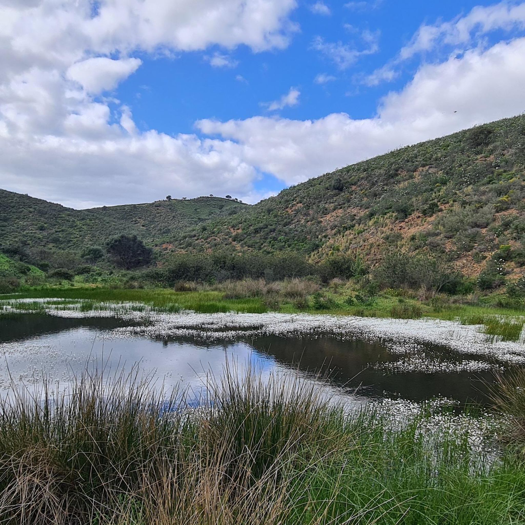
Along the Guadiana, the path meanders serenely, following the river's slow rhythm between hills of olive, almond, and fig trees. A former river of fishermen and miners, the Guadiana, called the "river of ducks" by the Romans, continues to connect Alentejo with Algarve and Portugal with Spain, a tranquil mirror of southern history and life.
2
0
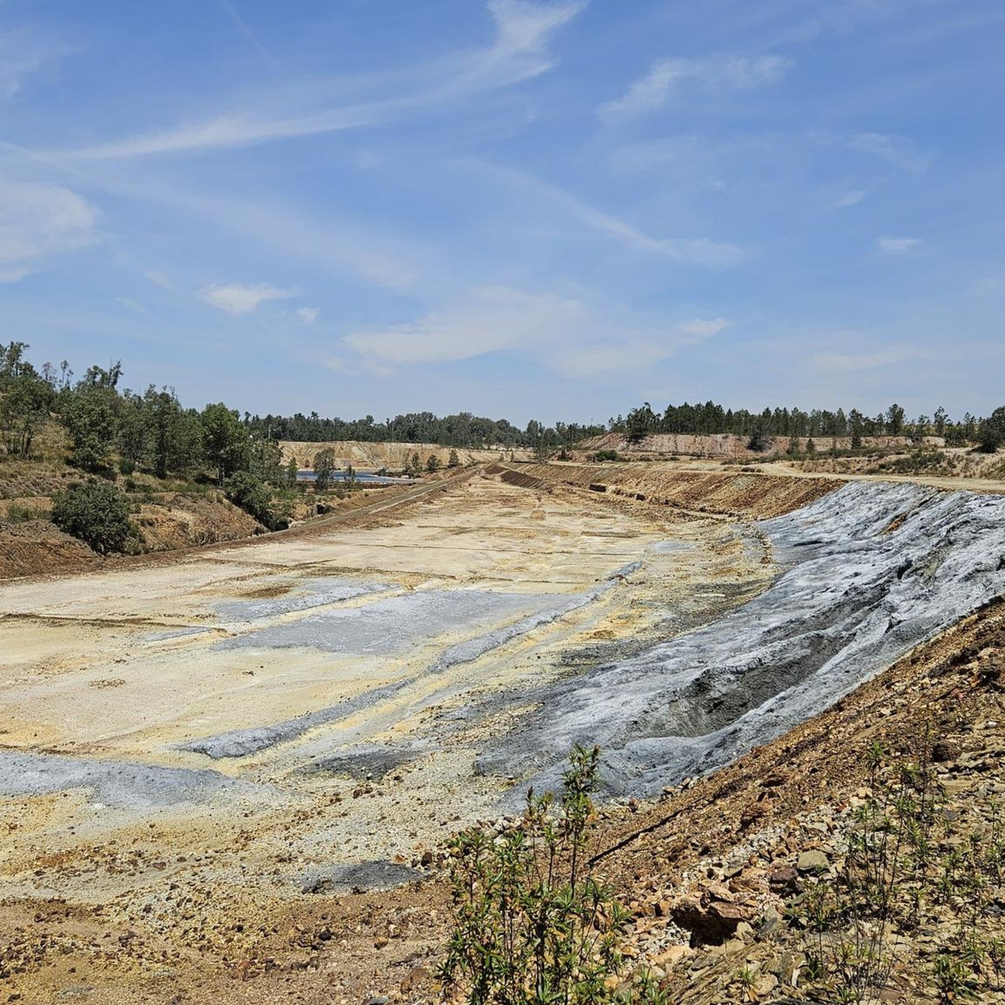
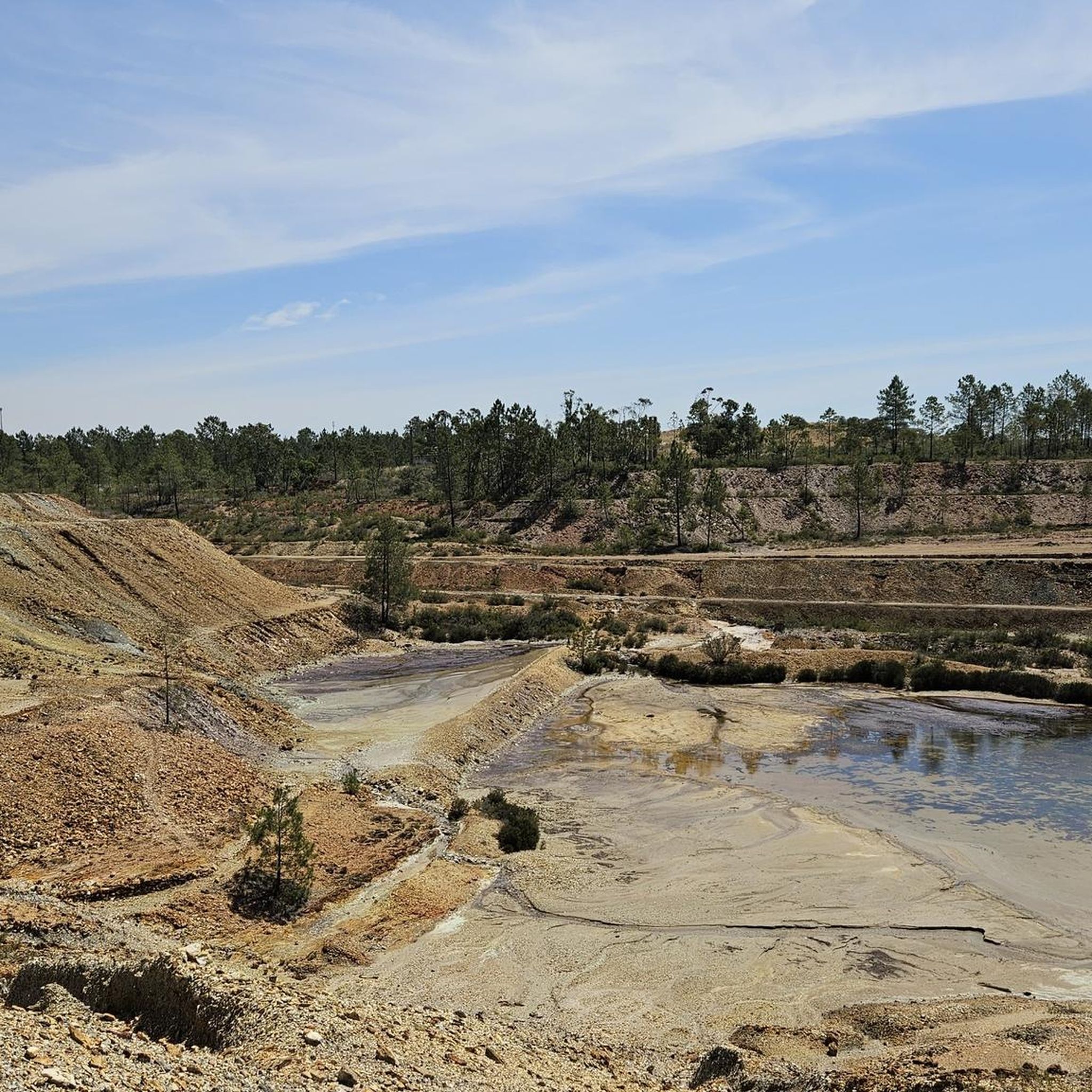
The old, abandoned copper mines resemble a lunar landscape: a strange and fascinating stage, illuminated by the reflections of copper-hued lakes. A road cuts through the landscape, guiding you along dirt roads. Streams and wells glow in unlikely colors, from copper to green to deep black. Signs warn of the dangers of the water, but nothing prevents your gaze from losing itself in the dramatic and unsettling beauty of the place.
2
0

You can access Pulo do Lobo from either side of the river: from Aldeia da Amendoeira, on the Mértola-Beja road (left bank), or from Serpa, in the village of Vale de Poços, where you'll find signs indicating exactly where to turn right (right bank). Both paths are well signposted, and both have several viewpoints. The best view of the waterfall, however, is undoubtedly from the viewpoint on the right bank. Further ahead, you'll see Pego dos Sáveis, the spot where the water suddenly calms down again, forming a tranquil lake.
4
0

Pulo do Lobo. This is the largest waterfall in southern Portugal and is located on the Guadiana River, upstream from Mértola. The waters fall from a height of over 20 metres and, surrounded by a sea of foam, descend the rocky gorge to the bottom, emptying into a lake between the rocks. The banks of the waterfall are so narrow that, according to legend, even a wolf could cross them in one leap. Hence the name Pulo do Lobo. The landscape of Pulo do Lobo is spectacular, the riverbed after the waterfall is completely exposed, in rock, between which the Guadiana River meanders, in a groove created over thousands of years. Access to Pulo do Lobo can be from the east or west. To the east, take a detour on the road that connects Serpa to Mértola. Access to the waterfall is difficult and you have to walk, crossing the rocky riverbed to reach the waterfall. We recommend caution. To the west, take a detour on the road that connects Beja to Mértola and continue to the village of Amendoeira da Serra, following the signs to Pulo do Lobo. You will then reach Herdade de Pulo do Lobo, open the gate and it is about 1000m on a dirt road to the waterfall. Access is prohibited to heavy vehicles. Access to the waterfall from the west is easier, and there is even a structure to better observe the waterfall.
5
0
To get a better view of the waterfall, choose the viewpoint on the right bank.
4
0

The route is not easy, nor familiar, nor for people without any preparation as it says in the generic. The route is difficult and is characterized, in the area next to the river, by the permanent crossing of masses of rocks that are difficult to overcome, it is not familiar at all and requires someone physically fit.
1
1

Boardwalks have been built on the eastern side for several years to make it easier to get to the waterfall and admire it from a safe distance. A really great project, which unfortunately seems to have stalled. The footbridges are still closed, although most of them are already accessible. The footbridges down to the water and above the reservoir are accessible (but still closed), the footbridges to the other side, downstream, are not yet completed.
2
1
Frequently Asked Questions
What are some of the most striking natural features to see around Santana De Cambas?
The region is rich in diverse natural features, primarily shaped by the Guadiana River. You can witness the dramatic Pulo do Lobo Waterfall, where waters plunge over 20 meters into a rocky gorge. For serene riverine landscapes, explore the Guadiana Riverside at Bombeira or the tranquil Pego dos Sáveis, a calm lake formed by the river. Additionally, viewpoints like the View of the Guadiana River in the Guadiana Site of Community Importance offer expansive vistas of the Alentejo landscape.
Are there family-friendly natural monuments or activities in the Santana De Cambas area?
Yes, the Guadiana Riverside at Bombeira is noted as family-friendly, offering a serene environment by the river. The Guadiana Valley Natural Park, which encompasses many of these sites, provides various hiking trails suitable for different skill levels, making it possible to find routes enjoyable for families. The wooden walkways recently added at Pulo do Lobo also enhance accessibility for visitors.
What kind of outdoor activities can I do near the natural monuments in Santana De Cambas?
The area around Santana De Cambas is excellent for outdoor enthusiasts. You can find numerous hiking and cycling opportunities. For hiking, explore routes like the 'Mina de São Domingos – Copper lakes of the mine loop' or shorter, easy walks such as the 'Tapada Grande Bar – Rest area by the lake loop'. Cyclists can enjoy routes like the 'Rest area by the lake – Dirt road through the mines loop'. You can find more details on these activities in the hiking guide and cycling guide for Santana De Cambas.
Are there any historical or cultural sites integrated with the natural landscape?
While primarily natural, the region features sites where human history intertwines with nature. The Guadiana Valley Natural Park includes the PR10 – Rota do Minério, a trail that passes through a former mining complex, blending natural beauty with historical insights. Additionally, the Mina de São Domingos, though not strictly a natural monument, is a former mining complex with a unique, almost 'apocalyptic' landscape shaped by both human activity and natural processes, offering a powerful natural-industrial aesthetic.
What is the best time of year to visit the natural monuments around Santana De Cambas?
The Alentejo region generally experiences hot, dry summers and mild winters. Spring (March to May) and autumn (September to November) are often considered the best times to visit, as the weather is pleasant for outdoor activities like hiking and exploring. During these seasons, the landscapes are vibrant, and temperatures are comfortable, making for an enjoyable experience at sites like Pulo do Lobo and the Guadiana Riverside.
Can I bring my dog to the natural monuments and trails?
The Guadiana Valley Natural Park, which encompasses many of these natural monuments, is generally dog-friendly. However, it's always advisable to keep dogs on a leash, especially in protected areas, to protect local wildlife and ensure a pleasant experience for all visitors. Specific regulations might apply to certain trails or sensitive areas, so checking local signage is recommended.
Are there any viewpoints offering panoramic views of the region?
Yes, the View of the Guadiana River in the Guadiana Site of Community Importance is a popular viewpoint offering expansive views of fields, hills, trees, and local birdlife, providing a comprehensive perspective of the surrounding landscape. Another excellent spot is the Beautiful path along the Guadiana, which meanders serenely and offers picturesque river views.
What should I wear when hiking or exploring the natural monuments?
Given the varied terrain, comfortable hiking shoes with good grip are essential. Layers of clothing are advisable, as temperatures can change throughout the day, especially during spring and autumn. Sun protection, including a hat and sunscreen, is important, particularly during warmer months. Bringing sufficient water is also crucial, as some areas may have limited facilities.
Are there any easy walks or trails suitable for beginners?
Yes, within the broader network of trails, you can find easier options. For instance, the 'Tapada Grande Bar – Rest area by the lake loop' is an easy hiking route near Mina de São Domingos. The wooden walkways at Pulo do Lobo also make parts of the visit more accessible. When planning, look for trails marked as 'easy' or 'family-friendly' to ensure a comfortable experience.
What is the Guadiana Valley Natural Park, and how does it relate to these monuments?
The Guadiana Valley Natural Park is a protected area that encompasses many of the natural monuments around Santana De Cambas. It's renowned for its diverse landscapes and rich biodiversity along the Guadiana River. The park provides a serene environment for nature lovers, offering opportunities for observing local flora and fauna and exploring various hiking trails that connect these natural sites.
Where can I find parking when visiting these natural monuments?
Access to natural monuments like Pulo do Lobo often includes designated parking areas. For example, when accessing Pulo do Lobo from the west, you can reach Herdade de Pulo do Lobo, where parking is available, followed by a dirt road to the waterfall. For other trails and viewpoints, parking facilities are typically available at trailheads or nearby villages like Santana de Cambas or Mértola. Always check local signage for specific parking instructions.
Are there any unique geological formations to observe?
Absolutely. The Pulo do Lobo Waterfall is a prime example, where the Guadiana River has sculpted a dramatic, narrow gorge over millennia. The riverbed after the waterfall is completely exposed in rock, showcasing how the river has carved a meandering groove. This area offers a fascinating insight into the geological power of water.
Most popular routes around Santana De Cambas
Most popular attractions around Santana De Cambas

Get inspired with the komoot mobile app


Explore more
Extend your search for the best caves by checking out these guides of the top ones around Santana De Cambas:
