The best walks and hikes around Shepherdstown
5.0
(1)
19
hikers
8
hikes
Hiking around Shepherdstown offers diverse terrain along the Potomac River, characterized by Appalachian foothills and historic farmland. The region features limestone bluffs and extensive trail networks, including sections of the Chesapeake & Ohio Canal Towpath. These natural features provide a varied landscape for outdoor exploration.
Best hiking trails around Shepherdstown
- The most popular hiking route is Snavely Ford Antietam National Battlefield Trail, a 11.4 miles (18.3 km) trail that takes 4 hours 49 minutes to complete. This moderate route…
Last updated: October 14, 2026
1
hikers
18.3km
04:49
160m
190m
The Snavely Ford Antietam National Battlefield Trail offers a moderate 11.3-mile hike through historic battlefields and along Antietam Creek
21.5km
05:28
60m
70m
Hike the C&O Canal Trail from Shepherdstown to Harpers Ferry, enjoying historic landmarks, river views, and wildlife spotting.

11.6km
02:58
40m
30m
Hike 7.2 miles along the historic C&O Canal Towpath from Taylors Landing to McMahon's Mill, enjoying river views and historic locks.
1.67km
00:25
10m
0m
This easy 1.0-mile hike on the Chesapeake and Ohio Canal Towpath offers historical structures and Potomac River views.
850m
00:14
10m
10m
Enjoy an easy 0.5-mile hike on the Ferry Hill Trail in Washington County, Maryland, featuring forests, rivers, and historic landmarks.
Get access to more routes and recommendations from other explorers.
Already have an account?
Our route recommendations are based on thousands of hikes, rides, and runs completed by other people on komoot.
Start today with a free account
Your next adventure awaits.




Other adventures around Shepherdstown

Tips from the Community

The pedestrian path offers a beautiful view of the striking bridge piers from past days.
1
0

28 Sept 2025: staircase closed as they rebuild it
0
0

A paved elevated boardwalk stretches out along the water, giving you a fantastic view of the Potomac River. This spot can get pretty popular on summer weekends.
0
0

Dam No. 4 is located around mile 84 of the C&O Canal Towpath. Built in 1856, this dam was crucial for maintaining water levels for canal operations and remains an impressive structure along the river. The area around the dam is known for its scenic views and wildlife.
0
0
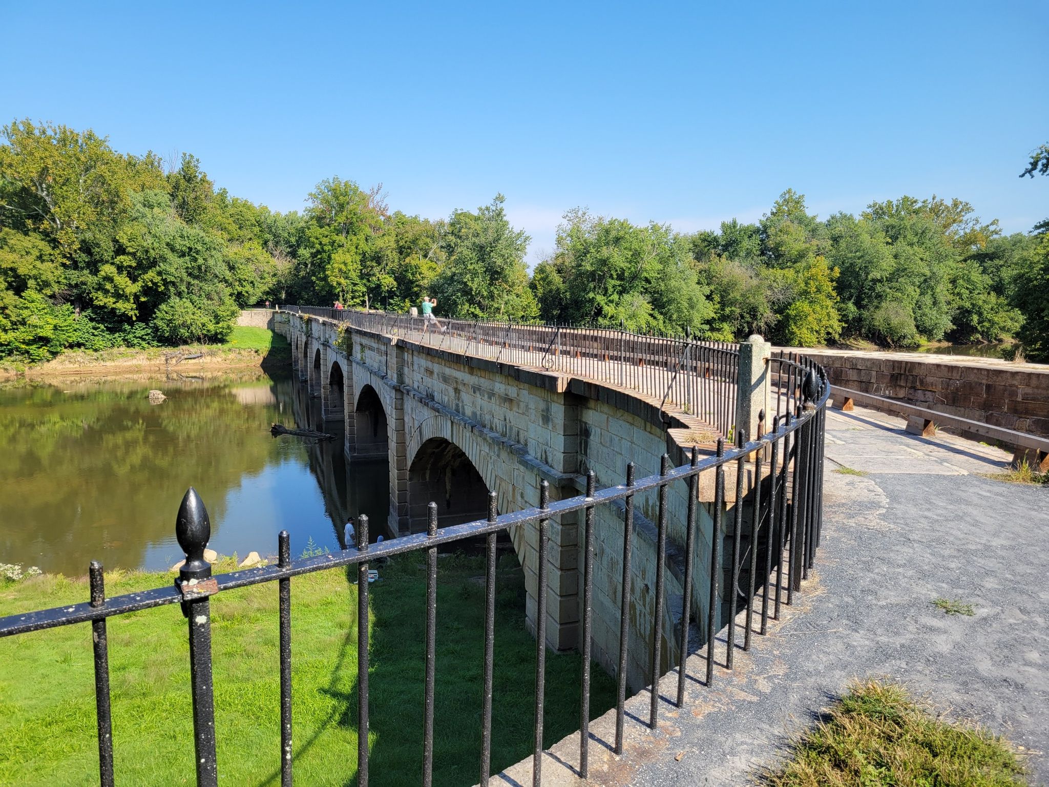
The Antietam Aqueduct was built in 1834 to carry canal boats over Antietam Creek. It is over 140 feet long and is one of many such aqueducts along the C&O Canal.
0
0
The Antietam Aqueduct, located at mile 69.4 of the C&O Canal Towpath, is a three-arch stone aqueduct that once carried the canal over Antietam Creek. Built in 1834, it is constructed from limestone quarried nearby and remains one of the best-preserved aqueducts along the canal. During the Civil War, it was near the site of Confederate troop movements before and after the Battle of Antietam in 1862. Though it suffered some damage over the years, it has been fully restored and now serves as a scenic and historic stop along the towpath, offering great river views and picnic spots.
0
0
Dam No. 4 is located around mile 84 of the C&O Canal Towpath. Built in 1856, this dam was crucial for maintaining water levels for canal operations and remains an impressive structure along the river. The area around the dam is known for its scenic views and wildlife, making it a nice spot to pause before continuing on your ride.
0
0

to get from trail to Harper's Ferry, you have to go up these stairs. There are bike racks at the base, or you carry your bike up with you
0
0
Frequently Asked Questions
What types of hiking trails can I find around Shepherdstown?
Shepherdstown offers a diverse range of hiking experiences, from flat, shaded towpaths along the Potomac River to more challenging routes through historical battlefields and Appalachian foothills. You'll find trails suitable for various fitness levels, including easy strolls and moderate to difficult hikes. The region is known for its natural beauty and historical significance, providing a unique backdrop for outdoor exploration.
Are there any easy, family-friendly hikes in the Shepherdstown area?
Yes, Shepherdstown has several easy trails perfect for families. The Chesapeake and Ohio Canal Towpath offers a flat, shaded experience along the Potomac River, ideal for a leisurely walk. Another great option is the Ferry Hill Trail, which is also rated as easy and provides a pleasant outing for all ages. These trails are generally well-maintained and offer scenic views without significant elevation changes.
Can I bring my dog on the hiking trails near Shepherdstown?
Many trails in the Shepherdstown area are dog-friendly, especially those along the C&O Canal Towpath and in natural preserves. For example, the Chesapeake and Ohio Canal Towpath is a popular choice for hikers with dogs. Always remember to keep your dog on a leash, clean up after them, and check specific trail regulations before heading out, as rules can vary by location.
What are some notable historical or natural attractions to see while hiking?
Shepherdstown's trails are rich in history and natural beauty. You can explore the historic grounds of the Antietam National Battlefield, which features a network of paths. The Snavely Ford Antietam National Battlefield Trail is a great way to experience this area. Along the Potomac River, don't miss the Big Slackwater section of the C&O Canal, an elevated boardwalk offering excellent river views. The View of the Potomac River from the Shepherdstown Bridge also provides a fantastic vista.
Are there any loop hikes available around Shepherdstown?
While many trails in the area are out-and-back, you can create loop experiences by combining sections of the extensive C&O Canal Towpath with other paths or by utilizing access points. For instance, you could plan a loop starting from Shepherdstown along the C&O Canal and exploring nearby areas. The Snavely Ford Antietam National Battlefield Trail offers a substantial route that can be adapted for varied exploration within the battlefield's network.
What is the best time of year to go hiking in Shepherdstown?
Shepherdstown offers enjoyable hiking year-round, but each season has its unique charm. Spring brings vibrant wildflowers, especially in places like Yankauer Nature Preserve. Fall is spectacular with the changing foliage of the Appalachian foothills. Summer is great for shaded trails along the Potomac, with opportunities for swimming. Winter hiking can be peaceful, though some trails might be less accessible depending on snow or ice. Always check local conditions before you go.
How long are the typical hiking trails in this region?
The hiking trails around Shepherdstown vary significantly in length. You can find shorter, easy walks like the Ferry Hill Trail at under a mile, or longer, more challenging routes. For example, the C & O Canal Trail: Shepherdstown to Harpers Ferry is over 13 miles, and the Snavely Ford Antietam National Battlefield Trail is over 11 miles. This variety allows you to choose a hike that fits your desired distance and time commitment.
Are there any trails suitable for winter hiking in Shepherdstown?
Yes, many of the trails, particularly the flat and well-maintained sections of the C&O Canal Towpath, are suitable for winter hiking. The Taylors Landing to McMahon's Mill via C and O Canal Trail is a moderate option that can be enjoyed in winter. Always be prepared for colder temperatures, potential ice, and shorter daylight hours. Trails through forested areas can offer some protection from wind.
What do other hikers enjoy most about hiking in Shepherdstown?
The komoot community highly rates the hiking experiences around Shepherdstown, with an average score of 5.0 stars. Reviewers often praise the region's unique blend of natural beauty and historical significance, particularly the scenic Potomac River views and the well-preserved C&O Canal Towpath. The accessibility of trails for various skill levels and the peaceful atmosphere are also frequently highlighted.
Are there any trails that offer great viewpoints of the Potomac River or surrounding landscapes?
Absolutely! The Potomac River is a central feature of the region, and many trails offer stunning views. The View of the Potomac River from the Shepherdstown Bridge is a popular spot. Additionally, sections of the C&O Canal Towpath, such as the Big Slackwater, provide excellent river vistas from an elevated boardwalk. For more expansive views, the nearby Appalachian Trail, particularly around Maryland Heights near Harpers Ferry, offers panoramic scenes of the river and valley.
Is parking readily available for trail access in Shepherdstown?
Yes, parking is generally available at various access points along the C&O Canal Towpath and at trailheads for other routes. For instance, there are designated parking areas near Lock No. 38 for C&O Canal access in Shepherdstown. When planning your hike, it's always a good idea to check specific trailhead information for parking details to ensure a smooth start to your adventure.
Most popular attractions around Shepherdstown

Get inspired with the komoot mobile app


Explore more
Browse the best Hikes in other regions.
