The best walks and hikes in Reserva Ecológica Cotacachi-Cayapas
5.0
(115)
724
hikers
4
hikes
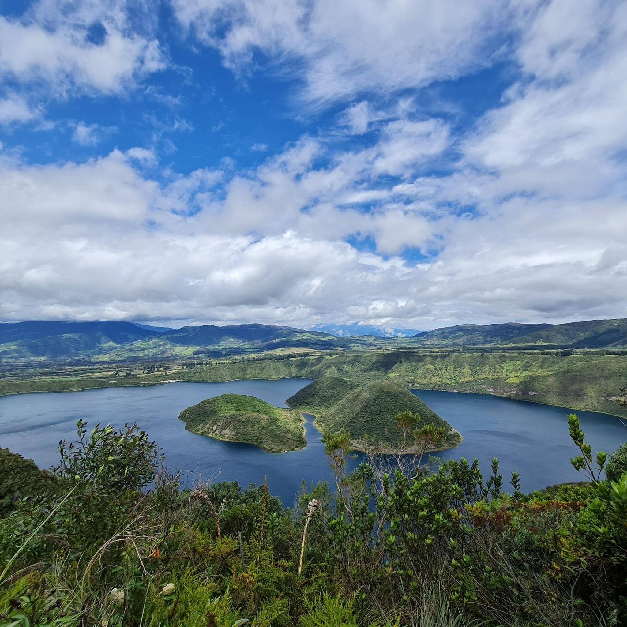
Hiking in Reserva Ecológica Cotacachi-Cayapas offers diverse terrain, ranging from high-altitude páramos to cool cloud forests and dense lowland tropical rainforests. The region is characterized by its volcanic landscapes, including the iconic Cotacachi Volcano and the stunning Cuicocha Lake, a crater lake formed within a collapsed caldera. Hikers can explore varied ecosystems across a significant altitudinal gradient, encountering volcanic lakes and lush forests.
Best hiking trails in Reserva Ecológica Cotacachi-Cayapas
- The most popular hiking route is Cuicocha Lake Trail –…
Last updated: July 15, 2026
4.9
(109)
640
hikers
Moderate hike. Good fitness required. Easily-accessible paths. Suitable for all skill levels.
5.0
(2)
58
hikers
Moderate hike. Good fitness required. Easily-accessible paths. Suitable for all skill levels.

Sign up for free
5.0
(1)
14
hikers
8.88km
03:05
490m
480m
Moderate hike. Good fitness required. Easily-accessible paths. Suitable for all skill levels.
5.0
(3)
12
hikers
Easy hike. Great for any fitness level. Easily-accessible paths. Suitable for all skill levels.
Our route recommendations are based on thousands of hikes, rides, and runs completed by other people on komoot.
Start today with a free account
Your next adventure awaits.
Login or Signup
Popular around Reserva Ecológica Cotacachi-Cayapas
Tips from the Community

Being in this place and having the feeling of turning around and knowing everything you walked, is beautiful. A different view of everything and the most refreshing and delicious breeze there is.
0
0

On this section of the hiking trail that runs all the way around Laguna Cuicocha, after climbing numerous steps and through lush Andean flora, you reach a ridge path with fantastic views of the lagoon and the Otavalo plain
0
0

Arriving from Otavalo without your own car: From the bus terminal, take the bus to Cotacachi or Quiroga. Buses run every 15-20 minutes. Just ask for Laguna at the terminal and someone will direct you to the right bus. Cost per ride: $0.4. The bus driver will drop you off at a taxi rank in Cotacachi or at the central park in Quiroga. From there, the only way to get to the lagoon is by taxi, as there are no buses going there. A taxi will cost around USD 5-6. For the return trip, it's best to use the taxi driver's phone number to call him for the return trip, as the lagoon is pretty deserted and there aren't really any taxis around. The price for the return trip is the same as for the outward trip. It would also be possible to hitchhike back at least to Quiroga, since the road from the lagoon goes through Quiroga. From there or Cotacachi, take the $0.4 bus to Otavalo again. The buses also leave here very regularly.
0
0

It's not allowed to camp on the trail, but... Noone checks if you do :)
1
0

Circular hike around the "guinea pig lagoon". The easiest way to get there from Otavalo is by bus to Quiroga and then by taxi from the parque central there ($5)
2
0
Frequently Asked Questions
How many hiking trails are available in Reserva Ecológica Cotacachi-Cayapas?
There are 4 hiking trails documented in Reserva Ecológica Cotacachi-Cayapas on komoot, offering a range of experiences from easy walks to moderate treks. These routes are highly rated by the komoot community, with an average score of 5.0 stars.
What types of landscapes can I expect to see while hiking in the reserve?
The reserve boasts an incredible diversity of landscapes due to its vast altitudinal range. You can experience high-altitude páramos, cool, misty cloud forests, and dense lowland tropical rainforests. A prominent feature is Cuicocha Lake, a stunning crater lake, and the iconic Cotacachi Volcano.
Are there any easy hiking routes suitable for beginners or families?
Yes, there is one easy route available. The Cuicocha Lake Trail – Cuicocha Crater Lake loop from Quiroga is a 2.2 km path that takes approximately 36 minutes to complete, offering a gentle introduction to the area's beauty.
What are the most popular hiking areas or landmarks within the reserve?
The most popular area for hiking is undoubtedly around Cuicocha Lake. Trails like the Cuicocha Lake Trail – View of Lake Cuicocha loop from Parqueadero Laguna Cuicocha offer expansive views of the crater lake and its unique geothermal activity.
Can I find circular hiking routes in Reserva Ecológica Cotacachi-Cayapas?
Yes, all the documented routes in the reserve are circular. For example, the Cuicocha Crater Lake – Cuicocha Lake Trail loop from Parqueadero Laguna Cuicocha is a moderate 7.3 km loop providing scenic views around the lake's perimeter.
What kind of wildlife can I expect to see while hiking?
Reserva Ecológica Cotacachi-Cayapas is a biodiversity hotspot. Hikers have opportunities for wildlife watching, including over 700 species of birds like toucans and quetzals, and mammals such as spectacled bears, pumas, and Andean foxes. The cloud forests are particularly rich in unique flora and fauna.
What do other hikers enjoy most about the trails in Reserva Ecológica Cotacachi-Cayapas?
The trails in Reserva Ecológica Cotacachi-Cayapas are highly rated by the komoot community, with an average score of 5.0 stars from over 100 reviews. Reviewers often praise the stunning volcanic landscapes, the serene beauty of Cuicocha Lake, and the diverse ecosystems encountered along the paths.
Are there any challenging hikes for experienced individuals?
While the komoot guide currently lists moderate trails as the most challenging, the region itself offers more demanding opportunities. The iconic Cotacachi Volcano, reaching 4,944 meters, provides challenging hiking and climbing for experienced individuals seeking panoramic views, though specific komoot routes for this are not detailed here.
What are the typical elevations encountered on hikes in the reserve?
The reserve spans a significant altitudinal gradient, from 35 meters to 4,939 meters above sea level. While the documented komoot routes around Cuicocha Lake typically involve elevation gains of up to 535 meters, the broader reserve includes high-altitude páramos and lower tropical rainforests, offering varied elevation experiences.
Are there any specific natural features like waterfalls or volcanic lakes to explore?
Yes, the reserve is known for its volcanic landscapes and water systems. Cuicocha Lake, a stunning crater lake, is a primary natural feature. The reserve also protects vital water systems, and hikers may encounter volcanic lakes, waterfalls, and rapids throughout the area.
What is the best way to experience the cloud forests in the reserve?
To experience the cloud forests, you'll want to explore trails that traverse the mid-elevation zones of the reserve. These misty forests are known for their lush vegetation, including epiphytes like orchids and bromeliads, and are excellent for birdwatching. While specific cloud forest routes aren't detailed in this guide, the region's diverse ecosystems ensure opportunities to immerse yourself in these unique environments.
Most popular routes in Reserva Ecológica Cotacachi-Cayapas

Get inspired with the komoot mobile app


