Easy hikes and walks around Stetteldorf am Wagram
4.5
(468)
2,926
hikers
294
hikes
Easy hiking trails around Stetteldorf am Wagram are characterized by their location on the Wagram ridge in Lower Austria, offering a blend of scenic landscapes. The region features extensive vineyards, rolling hills, and open farmland, providing diverse hiking experiences. From the Wagram ridge, hikers can enjoy views over the Tullnerfeld plain, with trails often weaving through viticultural areas.
Best easy hiking trails around Stetteldorf am Wagram
- The most popular easy hiking route is Absdorf Observation Platform – Kellergasse Absdorf loop…
Last updated: June 30, 2026
1.0
(1)
7
hikers
Easy hike. Great for any fitness level. Easily-accessible paths. Suitable for all skill levels.
5.0
(1)
11
hikers
3.02km
00:46
0m
0m
Easy hike. Great for any fitness level. Easily-accessible paths. Suitable for all skill levels.

Sign up for free
2
hikers
Easy hike. Great for any fitness level. Easily-accessible paths. Suitable for all skill levels.
8
hikers
Easy hike. Great for any fitness level. Easily-accessible paths. Suitable for all skill levels.
3.0
(6)
5
hikers
Easy hike. Great for any fitness level. Easily-accessible paths. Suitable for all skill levels.
Get access to more routes and recommendations from other explorers.
Sign up for free
Already have an account?
Our route recommendations are based on thousands of hikes, rides, and runs completed by other people on komoot.
Start today with a free account
Your next adventure awaits.
Login or Signup
Popular around Stetteldorf am Wagram
Other adventures around Stetteldorf am Wagram

Tips from the Community

Before this sacred wayside shrine, I would like to offer a brief spiritual impulse to the hiker / walker pausing here at the cross, which may perhaps be an inspiration to one or the other: + „Almighty, eternal God, who loves mankind. Fill us with the love that your Spirit gives us. Let us shape our lives in such a way that we do justice to our calling, make us witnesses of your truth for all people, and help us to bring all believers together in the unity of faith and the fellowship of peaceful coexistence.“
2
0

A beautiful tour along the Wagram. The connecting cycle paths (84, 841,...) are surprisingly well marked 😉
2
0
That's exactly why you go cycling...
2
0

It offers magnificent views of the flat Tullnerfeld and, on clear days, as far as the foothills of the Alps. Accessible from below via a marked, narrow hiking trail and steps.
2
0
Here, right next to the Great Tullnerfeld circular hiking trail 675, you will find this rest bench with a beautiful cross in the background.
2
0
A beautiful wayside cross on the way to the Wagram edge, the Great Tullnerfeld circular hiking trail 675 passes by here.
4
0
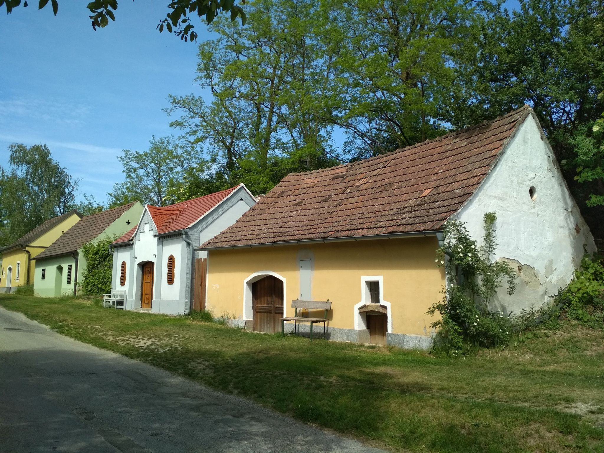
The cellar lanes in the Wagram are all beautiful, like this one, which is located on the Great Tullnerfeld circular hiking trail 675.
3
0
If the weather is good, you can enjoy a beautiful view over the "wide land" of Lower Austria from here, located on the Great Tullnerfeld circular hiking trail 675.
3
0
Frequently Asked Questions
How many easy hiking trails are available around Stetteldorf am Wagram?
There are over 200 easy hiking trails around Stetteldorf am Wagram. These routes are characterized by minimal elevation changes and generally gentle terrain, making them accessible for a wide range of hikers.
What kind of terrain can I expect on easy hikes in Stetteldorf am Wagram?
Easy hikes in Stetteldorf am Wagram primarily feature gentle slopes, extensive vineyards, and open farmland. You'll often find trails weaving through viticultural areas and along the Wagram ridge, offering picturesque views over the Tullnerfeld plain. The routes typically have very little ascent, making them comfortable for relaxed walks.
Are there any easy circular routes for hiking in the area?
Yes, Stetteldorf am Wagram offers several easy circular routes. A popular option is the Absdorf Observation Platform – Kellergasse Absdorf loop from Absdorf-Hippersdorf, which is about 5.7 km long and takes you through local vineyards. Another great choice is the Gaisrucker Kellergasse – Leeberg Hill Lookout loop from Pettendorf, a 5 km trail offering views from Leeberg Hill.
What are some family-friendly easy hiking options in Stetteldorf am Wagram?
The region is well-suited for families. The "Tut gut!"-Step Path in Stetteldorf am Wagram is an excellent family-friendly option, offering a pleasant loop of about 3.5 km with minimal elevation changes. Many of the easy trails, like the Schmida Bridge loop from Absdorf-Hippersdorf, are short and gentle, perfect for walks with children.
Are there any historical landmarks or interesting sights along the easy trails?
Yes, many easy hiking paths incorporate historical landmarks and scenic points. You might pass by Juliusburg Castle, a Renaissance castle on the Wagram edge. The region also offers views of the wide Tullnerfeld plain and features charming Kellergassen (wine cellar lanes) like those found on the Kellergasse Stetteldorf loop.
What do other hikers say about the easy trails in Stetteldorf am Wagram?
The easy trails in Stetteldorf am Wagram are highly rated by the komoot community, with an average score of 4.5 stars from over 450 reviews. Hikers often praise the picturesque vineyard landscapes, the well-maintained paths, and the relaxed atmosphere, making them ideal for enjoyable and accessible outdoor experiences.
Can I find places to eat or drink along the hiking routes?
Yes, the region is known for its culinary traditions. Many hiking paths pass through villages where you can find traditional Austrian wine taverns, known as "Heurigen," in places like Starnwörth and Stetteldorf. These offer opportunities for refreshment and to experience local food and wine.
What is the best time of year to go easy hiking in Stetteldorf am Wagram?
The spring and autumn months are particularly pleasant for easy hiking in Stetteldorf am Wagram. Spring brings blooming vineyards and mild temperatures, while autumn offers vibrant fall colors and the opportunity to experience the local wine harvest season at a Heuriger. Summer is also suitable, but it's advisable to hike in the mornings or late afternoons to avoid the midday heat.
Are there any less crowded easy hiking options available?
While popular routes like the Absdorf loops are well-loved, the extensive network of over 200 easy trails means you can often find quieter paths. Exploring some of the shorter village loops or less-trafficked vineyard paths can offer a more serene experience, especially during weekdays.
Is parking available near the trailheads for easy hikes?
Yes, parking is generally available in the villages and towns that serve as starting points for these easy hikes, such as Absdorf-Hippersdorf, Pettendorf, and Stetteldorf am Wagram. Specific parking information can often be found on individual route descriptions on komoot.
How can I access the easy hiking trails using public transport?
Stetteldorf am Wagram and surrounding villages are accessible by public transport, primarily by train or bus, connecting them to larger towns like Tulln. You can often reach trailheads directly from train stations or bus stops, making it convenient to start your hike without a car. It's recommended to check local transport schedules for specific routes and connections.
Most popular routes around Stetteldorf am Wagram
Most popular attractions around Stetteldorf am Wagram

Get inspired with the komoot mobile app


Explore more
Browse the best Hikes in other regions.
