Easy hikes and walks around Urgell
4.6
(225)
1,367
hikers
243
hikes
Easy hiking trails around Urgell traverse a diverse landscape characterized by Pyrenean peaks, lush valleys, and the River Segre. The region features significant elevation changes, from 800 meters to 2,650 meters, resulting in varied ecosystems ranging from alpine to Mediterranean species. Protected areas like Alt Pirineu Natural Park and Cadí-Moixeró Natural Park offer extensive networks of trails suitable for easy walks. This blend of natural features provides a rich environment for outdoor activities.
Best easy hiking trails around Urgell
- The…
Last updated: August 23, 2026
5
hikers
5.78km
01:38
130m
130m
Easy hike. Great for any fitness level. Easily-accessible paths. Suitable for all skill levels.
4.6
(7)
24
hikers
6.67km
01:55
160m
160m
Easy hike. Great for any fitness level. Easily-accessible paths. Suitable for all skill levels.

Sign up for free
3.0
(1)
10
hikers
7.32km
01:56
70m
70m
Easy hike. Great for any fitness level. Easily-accessible paths. Suitable for all skill levels.
4.0
(1)
4
hikers
7.16km
01:54
80m
80m
Easy hike. Great for any fitness level. Easily-accessible paths. Suitable for all skill levels.
8
hikers
6.83km
01:46
40m
40m
Easy hike. Great for any fitness level. Easily-accessible paths. Suitable for all skill levels.
5.0
(1)
2
hikers
5.80km
01:43
180m
180m
Easy hike. Great for any fitness level. Easily-accessible paths. Suitable for all skill levels.
7
hikers
3.82km
01:01
40m
40m
Easy hike. Great for any fitness level. Easily-accessible paths. Suitable for all skill levels.
3
hikers
5.77km
01:37
110m
110m
Easy hike. Great for any fitness level. Easily-accessible paths. Suitable for all skill levels.
4
hikers
4.80km
01:13
10m
10m
Easy hike. Great for any fitness level. Easily-accessible paths. Suitable for all skill levels.
6
hikers
2.72km
00:49
90m
90m
Easy hike. Great for any fitness level. Easily-accessible paths. Suitable for all skill levels.
Get access to more routes and recommendations from other explorers.
Sign up for free
Already have an account?
Our route recommendations are based on thousands of hikes, rides, and runs completed by other people on komoot.
Start today with a free account
Your next adventure awaits.
Login or Signup
Other adventures around Urgell


Tips from the Community

The Castell de Tàrrega was a medieval castle on a hill above the town of Tàrrega in Catalonia. It was probably built in the 11th century and played an important strategic role during the Reconquista. Today only a few remnants of the wall remain, but the castle hill offers a beautiful view over the town and the surrounding plain. Information boards commemorate the history of the once important fortress.
2
0

Along with the monasteries of Poblet and Santes Creus, this is one of the three pearls of Gothic architecture in Catalonia. You won't be disappointed.
0
0

The Ruins of San Vicente de Almenara are located in the municipality of Agramunt. This historic site is known for its remains of an ancient Romanesque church dating back to the 11th century. The ruins are located in a picturesque natural setting, ideal for hiking and mountain biking enthusiasts.
6
0
The Pilar de Almenara is a medieval defensive tower located at the top of the Sierra de Almenara, near Agramunt, in the Urgell region of Catalonia. This tower, dating from the 11th and 12th centuries, is 14 meters high and offers stunning panoramic views of the Urgell plain. The tower was used for surveillance and defense against Saracen raids and is similar to other Christian defensive towers in the region. From the top, on clear days, you can see as far as the Seu Vella de Lleida.
9
0


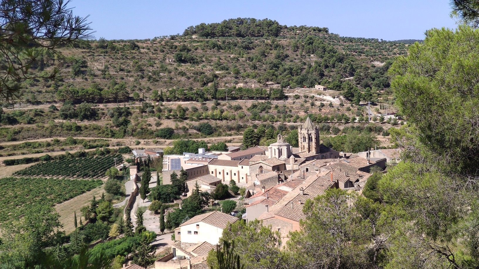
Beautiful medieval monastery from the Cistercian era, still inhabited by nuns.
0
0

The monastery of Santa María de Vallbona is a female Cistercian abbey founded in the 11th century and built in a mixture of Romanesque and Gothic styles. Together with the Poblet and Santes Creus monasteries, it forms the Cistercian Route.
0
0

Belltall is a nucleus of the municipality of Passanant i Belltall, in the region of Conca de Barberà (Tarragona). Of its heritage, the church of Sant Pere (19th century) stands out, with its neoclassical bell tower. As is usual in the area, some of its streets have vaulted sections. Belltall is known for having its own variety of garlic, the Belltall garlic, with a rounded shape, smaller than conventional garlic and flat at the bottom.
0
0
Frequently Asked Questions
How many easy hiking trails can I find in Urgell?
Urgell offers a wide selection of easy hiking trails, with 59 routes specifically categorized as easy. Overall, the region boasts over 180 hiking trails, catering to various skill levels amidst its diverse Pyrenean landscapes.
Are there any easy circular hiking routes in Urgell?
Yes, Urgell features several easy circular routes perfect for a relaxed day out. A popular option is the Pilar de Almenara - Circular Route, which is 3.6 miles (5.8 km) long and offers scenic views of the Urgell plain. Another great choice is the Hiking loop from Vallbona de les Monges, a 4.0 miles (6.5 km) path winding through varied valley landscapes.
What kind of views can I expect on easy hikes in Urgell?
Easy hikes in Urgell offer a variety of scenic views, from dramatic Pyrenean peaks and lush valleys to agricultural plains and the winding River Segre. Many routes provide panoramic vistas, such as those from the Pilar de Almenara - Circular Route, which overlooks the Urgell plain.
Are there any easy trails that pass by historical sites or cultural landmarks?
Absolutely. Urgell's rich history means many easy trails incorporate cultural exploration. You can find routes near ancient Romanesque churches or medieval structures. For instance, the Pilar de Almenara Tower is a notable defensive tower offering panoramic views, and the Ruins of San Vicente de Almenara are also nearby. The region also features charming villages and other historical points of interest.
Can I find easy hikes with waterfalls in Urgell?
Yes, Urgell offers easy hikes that lead to refreshing water features. The Salt del Durán – Salt del Duran Waterfall loop from Vilanova de Bellpuig is an excellent option, allowing you to enjoy the scenic beauty of a waterfall on an accessible route.
What do other hikers say about the easy trails in Urgell?
The easy trails in Urgell are highly rated by the komoot community, with an average score of 4.5 stars from over 100 reviews. Hikers often praise the region's diverse terrain, from Pyrenean foothills to serene valleys, and the well-maintained paths that make for an enjoyable and accessible outdoor experience.
Are there family-friendly easy hikes in Urgell?
Many easy trails in Urgell are suitable for families, offering gentle gradients and manageable distances. These routes often pass through varied landscapes, providing engaging scenery for all ages. The region's natural parks, like Alt Pirineu and Cadí-Moixeró, also feature recreational areas perfect for family outings.
What is the best season for easy hikes in Urgell?
Urgell's diverse climate means hiking is enjoyable across seasons. Spring and autumn offer pleasant temperatures and vibrant landscapes, ideal for easy walks. Summer provides warm weather, perfect for trails near water features, while winter can transform higher elevations into a snowy wonderland, though lower-altitude easy trails remain accessible.
Are there any easy hikes that explore unique local attractions, like street art?
Yes, Urgell offers unique easy hikes that combine nature with local culture. For a distinctive experience, consider the Penelles (village of murals) – Penelles Street Art Murals loop from Penelles. This route allows you to explore the charming village of Penelles, famous for its vibrant street art, on an easy 4.0 miles (6.5 km) loop.
Are there easy trails that pass through different types of ecosystems?
Due to significant elevation changes (from 800 to 2,650 meters), Urgell's easy trails can traverse highly variable vegetation, ranging from Mediterranean species in the valleys to more alpine flora in higher areas. This diversity ensures a constantly changing and interesting natural environment on your hike.
What kind of castles or religious buildings can I see near easy hiking routes?
Urgell is rich in historical architecture. Near easy hiking routes, you can explore various castles and religious buildings. Notable examples include the Monastery of Santa María de Vallbona, the Church of Santa Maria of Agramunt, and the Santuario del Tallat. For castles, you might encounter structures like Bellpuig Castle or Montclar Castle, adding a historical dimension to your walk.
Are there easy trails that are less crowded?
While some popular routes can see more visitors, Urgell's extensive network of trails, especially within protected areas like Alt Pirineu Natural Park, offers many opportunities for peaceful, less crowded easy walks. Exploring routes slightly off the main tourist paths or visiting during off-peak hours can enhance your tranquil experience.
What is the typical duration for an easy hike in Urgell?
Easy hikes in Urgell typically range from 1 to 2 hours, making them perfect for a leisurely outing. For example, the Hiking loop from Tàrrega is about 4.5 miles (7.3 km) and usually takes around 1 hour 56 minutes to complete, while shorter options like the Tossal Gros de Vallbona loop from Cap del Coll can be done in under an hour.
Most popular routes around Urgell
Most popular attractions around Urgell

Get inspired with the komoot mobile app


Explore more
Browse the best Hikes in other regions.
