The best walks and hikes around Härkingen
4.6
(3300)
18,553
hikers
866
hikes
Hiking around Härkingen offers diverse landscapes within the Solothurn region of Switzerland. The area is characterized by the Jura mountain range, featuring rolling hills, dense forests, and unique geological formations. Notable natural features include the tranquil Tüfelsschlucht (Devil's Gorge) with its waterfalls and moss-covered rocks, and various panoramic viewpoints. This varied terrain provides a range of hiking experiences for outdoor enthusiasts.
Best hiking trails around Härkingen
- The most popular hiking route is Schattenkänzeli Gazebo View – Tiefmatt Mountain Inn loop…
Last updated: June 27, 2026
4.8
(4)
38
hikers
Moderate hike. Good fitness required. Mostly accessible paths. Sure-footedness required.
5.0
(3)
15
hikers
7.32km
01:54
40m
40m
Easy hike. Great for any fitness level. Easily-accessible paths. Suitable for all skill levels.

Sign up for free
15
hikers
6.35km
01:37
20m
20m
Easy hike. Great for any fitness level. Easily-accessible paths. Suitable for all skill levels.
6
hikers
14.0km
04:33
500m
500m
Moderate hike. Good fitness required. Mostly accessible paths. Sure-footedness required.
5.0
(2)
11
hikers
6.63km
01:41
20m
20m
Easy hike. Great for any fitness level. Easily-accessible paths. Suitable for all skill levels.
Get access to more routes and recommendations from other explorers.
Sign up for free
Already have an account?
Our route recommendations are based on thousands of hikes, rides, and runs completed by other people on komoot.
Start today with a free account
Your next adventure awaits.
Login or Signup

Tips from the Community

The Alt Bechburg castle ruins are a worthwhile destination. The view from its walls is truly picturesque, enhancing the already medieval scenery. Several barbecue areas are available within the castle grounds, so barbecue fun is guaranteed. But beware! Entering Alt Bechburg is at your own risk. ⚠️ A sign right at the entrance specifically points this out. And rightly so! As inconspicuous as Alt Bechburg may appear at first glance, there are countless places where there is an acute danger of slipping and falling. The rear part of the complex, in particular, tempts you to explore, but has no safety measures. Particular caution is advised at the so-called "Felsentor" (rock gate). This is a passage through the rear castle wall, followed by a small square landing, from which a steep staircase once led down the rock into the depths. This ledge has no railing. Anyone careless (e.g., trying to take a spectacular photo or curiously peering into the depths) could fall. Weathered and broken steps at this spot also tempt curious explorers of the outer wall at the rear. Parents who want to spend an adventurous time with their children at Bechburg Castle should keep a very close eye on them. Otherwise, Alt Bechburg is a real eye-catcher (with its pitfalls) and a worthwhile destination at any time of year.
1
0

Ideal resting place with fire pit: carry barbecue food in your backpack!
1
0


I don't know what the photos were taken under, but after the torrential rain during my hike, the waterfall was a raging torrent through the rocks! But it's also clearly visible from above.
0
0

The second gorge after the Devil's Gorge. Not quite as spectacular, but still very beautiful.
0
0

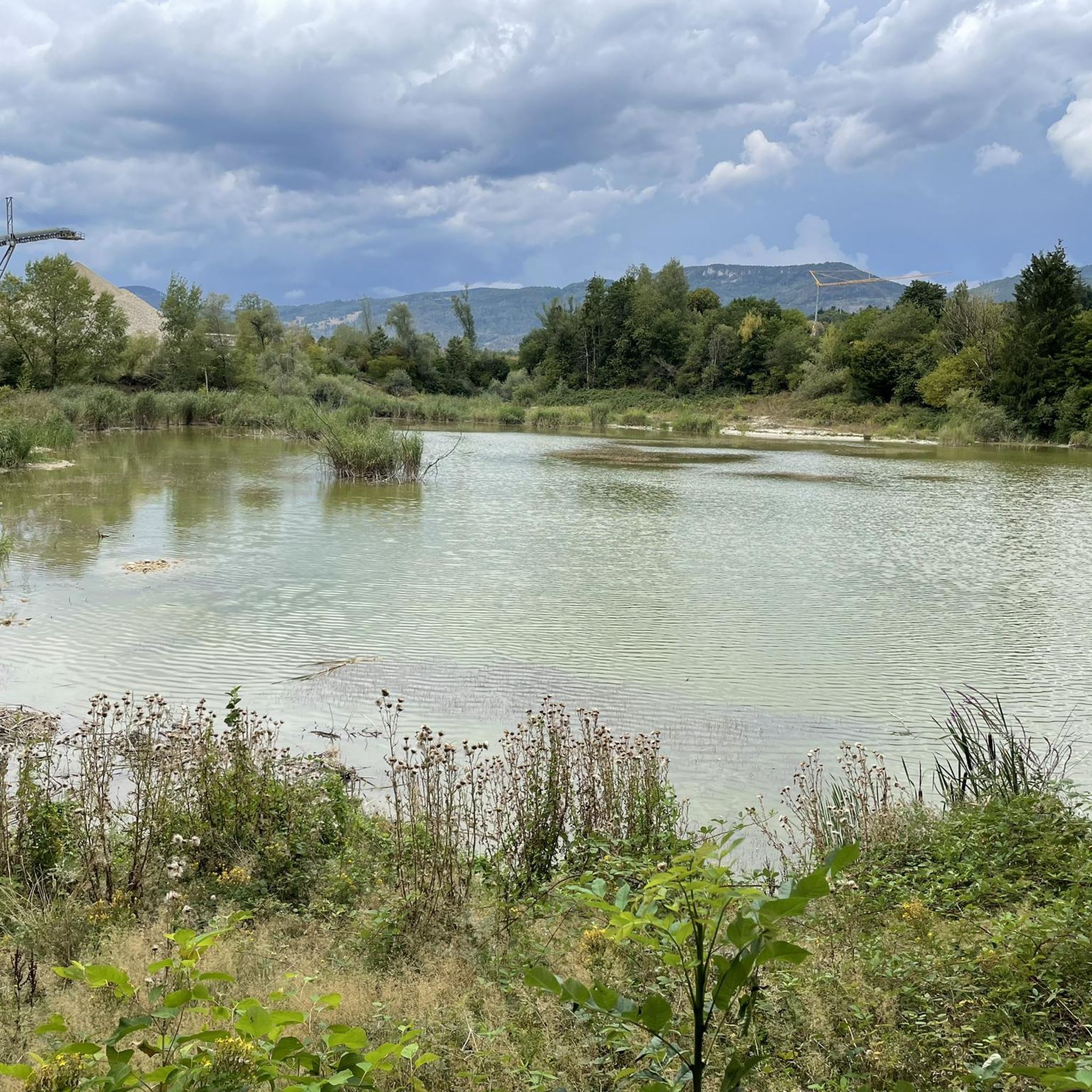
The common land biotope was designated in 1983 as part of the development plan for the Gunzgen/Boningen gravel mining area. It was protected as the Gunzgen Common Land Nature Reserve in 2012. The municipality of Gunzgen owns the area and, together with the canton, oversees its maintenance. The lake was created by gravel mining. It is fed by groundwater and springs. The excess water is diverted into a ditch in the south and seeps into the adjacent forest.
0
0
A tour to Blüemlismatt is always worthwhile. If the visibility is good, you can see the entire Alpine panorama. From Blüemlismatt, bikers can continue to the first Jura mountain range. Restaurant Blüemlismatt is closed on Mondays and Tuesdays.
0
0
Animals, wind chimes and recreation as well as hiking trails through the donkey enclosure.
0
0
Frequently Asked Questions
How many hiking trails are available around Härkingen?
Härkingen and its surrounding area offer a wide selection of routes, with nearly 900 hiking trails available. This includes over 400 easy routes, more than 400 moderate options, and around 50 challenging trails for experienced hikers.
Are there any family-friendly hiking trails in Härkingen?
Yes, Härkingen offers numerous easy trails suitable for families. For instance, the Bench in the Nature Reserve loop from Gunzgen is an easy 4.5-mile (7.3 km) hike with minimal elevation gain, perfect for a relaxed family outing. Another gentle option is the Hiking loop from Fulenbach, which is about 4 miles (6.4 km) long.
Can I find hikes with waterfalls in the Härkingen area?
Absolutely. The region is home to the captivating Tüfelsschlucht (Devil's Gorge), known for its rushing waterfalls and moss-covered rocks. A great way to experience this is the Schattenkänzeli Gazebo View – Tüfels Gorge loop from Egerkingen, an 8.7-mile (14.0 km) trail that leads directly through this impressive natural feature.
Are there any circular hiking routes available?
Many of the trails around Härkingen are designed as circular routes, allowing you to start and end at the same point. Examples include the popular Schattenkänzeli Gazebo View – Tiefmatt Mountain Inn loop from Egerkingen, a 7.1-mile (11.4 km) moderate hike, and the shorter Schattenkänzeli Gazebo View – Blüemlismatt Mountain Restaurant loop from Egerkingen.
What kind of viewpoints can I expect on hikes near Härkingen?
The Jura mountain range surrounding Härkingen offers several rewarding viewpoints. The most prominent is the Belchenflue Summit Viewpoint, which provides expansive panoramic views across the landscape. Many routes, such as those starting from Egerkingen, incorporate scenic vistas along forest paths and ridges.
Are there dog-friendly hiking trails in Härkingen?
Most hiking trails in the Härkingen region are dog-friendly, allowing you to explore the diverse landscapes with your canine companion. It's always recommended to keep dogs on a leash, especially in nature reserves or areas with livestock, and to carry water for them.
What are some interesting natural attractions or landmarks to see while hiking?
Beyond the stunning Tüfelsschlucht gorge, you can explore other natural monuments and historical sites. The Belchenflue Summit Viewpoint offers breathtaking vistas, while the Teufelsküche (Solothurn Jura) is another fascinating geological formation. You might also encounter the Neu-Falkenstein Castle Ruins or the Gwidemflue Ridge and World War I Fortifications, adding historical context to your hike.
Is it possible to reach hiking trailheads using public transport?
Yes, Härkingen and its neighboring towns like Egerkingen are generally well-connected by public transport. Many trailheads are accessible via bus or train, making it convenient to start your hike without a car. It's advisable to check local transport schedules for specific starting points.
What do other hikers say about the trails in Härkingen?
The hiking trails around Härkingen are highly regarded by the komoot community, boasting an impressive average rating of 4.6 stars from over 3000 reviews. Hikers frequently praise the diverse landscapes, from shady forests to impressive rock formations, and the well-maintained paths that cater to various skill levels.
Are there any advanced or challenging hiking trails for experienced hikers?
While Härkingen offers many easy and moderate options, there are also around 50 more challenging trails for those seeking a greater adventure. These routes often involve steeper ascents and longer distances within the Jura mountain range, providing a more strenuous workout and rewarding views.
What is the best time of year to go hiking in Härkingen?
Härkingen offers hiking opportunities throughout the year. Spring and autumn provide pleasant temperatures and vibrant scenery, with lush greenery in spring and colorful foliage in autumn. Summer is ideal for higher altitude trails, while some lower elevation paths can be enjoyed in winter, especially on clear, crisp days, though conditions may vary.
Are there options for less crowded hikes if I prefer solitude?
Given the extensive network of nearly 900 trails, it's possible to find less crowded options, especially on weekdays or by exploring some of the lesser-known paths away from the most popular attractions. The diverse terrain of the Jura mountain range allows for plenty of opportunities to discover tranquil forest walks and peaceful routes.
Where can I find information about local events or other activities in the region?
For information on local events, accommodations, or other activities in the broader region, you might find resources on the local tourism websites. For example, the Egerkingen Tourism website provides details on what to explore in the area: egerkingentourismus.ch.
Most popular routes around Härkingen
Most popular attractions around Härkingen

Get inspired with the komoot mobile app


Explore more
Browse the best Hikes in other regions.
