
The best running trails in Shenipsit State Forest
45
runners
20
runs
Jogging in Shenipsit State Forest offers a diverse landscape for runners, spanning over 7,000 acres across Ellington, Somers, and Stafford, Connecticut. The terrain features significant elevation changes, with hills and mountains rising 300–500 feet, including Soapstone Mountain at 1,075 feet. This provides opportunities for varied elevation training on trails that traverse oak-dominated forests and areas scattered with boulders. An extensive network of multi-use trails, old woods roads, and sections of the 50-mile Blue-Blazed Shenipsit Trail are available for running.
Best…
Last updated: August 20, 2026
6
runners
25.2km
03:12
480m
470m
Hard run. Very good fitness required. Mostly accessible paths. Some sure footedness required.
4
runners
14.3km
01:32
180m
180m
Moderate run. Good fitness required. Mostly paved surfaces. Suitable for all skill levels.

Sign up for free
2
runners
6.67km
00:43
110m
110m
Moderate run. Good fitness required. Mostly paved surfaces. Suitable for all skill levels.
3
runners
5.98km
00:38
70m
70m
Moderate run. Good fitness required. Mostly paved surfaces. Suitable for all skill levels.
4
runners
8.13km
00:50
30m
30m
Moderate run. Good fitness required. Mostly paved surfaces. Suitable for all skill levels.
Get access to more routes and recommendations from other explorers.
Sign up for free
Already have an account?
Our route recommendations are based on thousands of hikes, rides, and runs completed by other people on komoot.
Start today with a free account
Your next adventure awaits.
Login or Signup
Popular around Shenipsit State Forest
Frequently Asked Questions
What kind of terrain can I expect when running in Shenipsit State Forest?
Shenipsit State Forest offers a diverse and often challenging landscape. You'll find significant elevation changes, with hills and mountains rising 300–500 feet, including the prominent Soapstone Mountain at 1,075 feet. The trails traverse oak-dominated forests and are often scattered with boulders and large rocks, remnants from the last ice age, providing a rugged and varied running surface. Some sections of the Blue-Blazed Shenipsit Trail are known to be rocky, steep, and technical.
Are there any easy running routes for beginners in Shenipsit State Forest?
While many routes offer moderate challenges, there are options suitable for those looking for a less strenuous run. For example, the Running loop from Ellington is a moderate 5-mile (8.1 km) path with relatively low elevation gain, making it a good choice for a more relaxed experience.
What are some challenging running routes in Shenipsit State Forest?
For runners seeking a challenge, the forest's varied terrain provides ample opportunity. The Mountain Street loop from Ellington is a popular choice, covering 8.9 miles (14.3 km) with moderate elevation gain through varied forest terrain. The Blue-Blazed Shenipsit Trail, which crosses Soapstone Mountain, also offers sections known for being rocky, steep, and technical, ideal for experienced trail runners.
Are there any notable landmarks or viewpoints along the running trails?
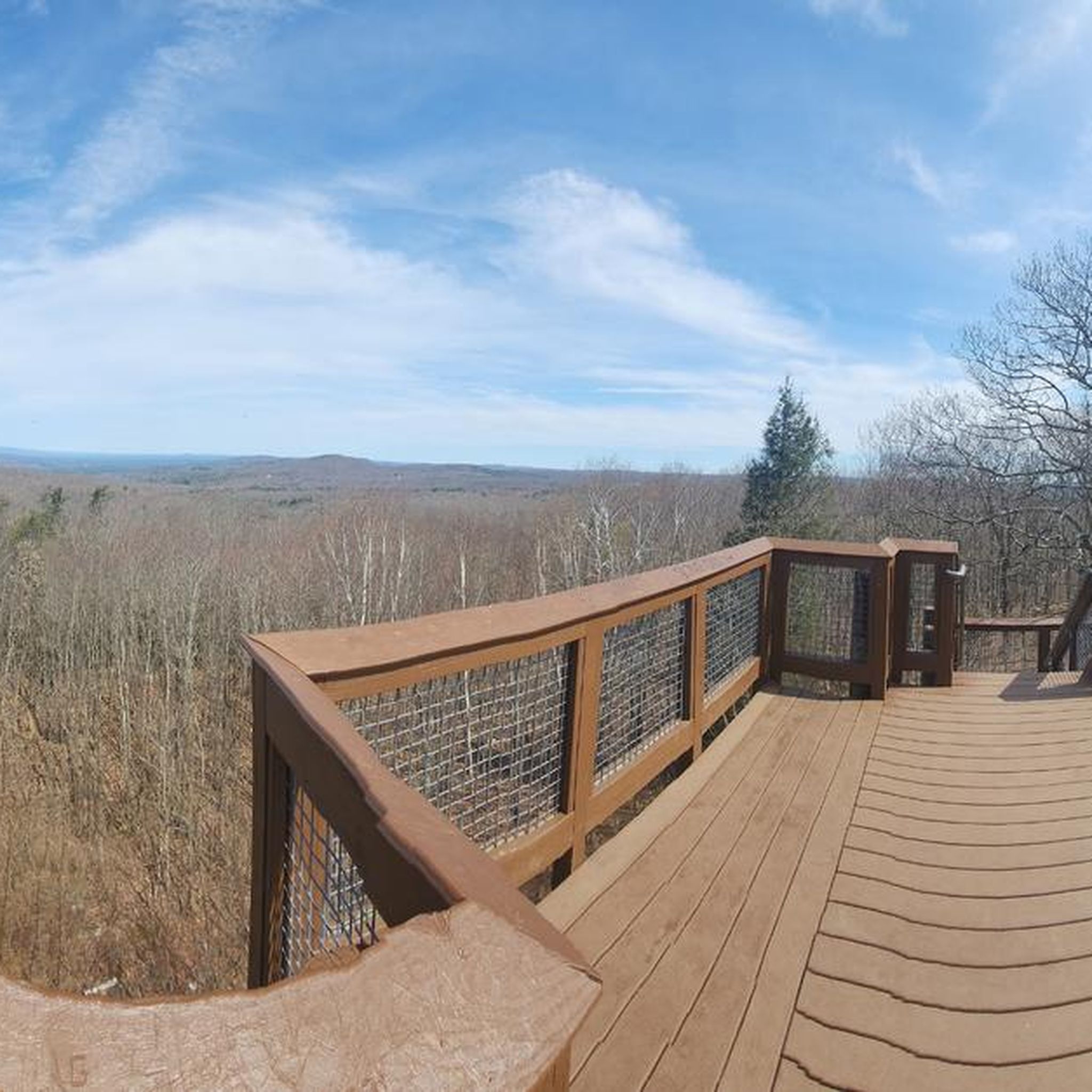
Yes, a key attraction is the Soapstone Mountain Observation Tower. From this vantage point, you can enjoy spectacular panoramic views across the Connecticut River Valley, reaching as far as the Springfield skyline. The forest also holds historical significance, including the site of a former soapstone quarry and remnants of charcoal mounds from the Colonial era.
Can I bring my dog on the running trails in Shenipsit State Forest?
Shenipsit State Forest is generally dog-friendly, allowing leashed dogs on its extensive trail system. It's always a good idea to check for any specific signage or regulations at trailheads, but most multi-use trails and old woods roads are suitable for running with your canine companion.
What is the best time of year to go running in Shenipsit State Forest?
The forest is beautiful year-round, but running is particularly scenic during the fall foliage season when the oak-dominated woodlands display vibrant colors. Spring and summer offer lush greenery and shaded trails, while winter can provide a unique experience, though some trails may be more challenging due to snow or ice. Always check local conditions before heading out.
Are there any circular running routes available?
Yes, many of the routes in Shenipsit State Forest are designed as loops, offering a convenient way to explore without retracing your steps. Examples include the popular Laurel Road Open Space loop from Ellington, a moderate 4.1 miles (6.6 km) path, and the Sandy Beach loop from Crystal Lake, which is 3.7 miles (5.9 km).
How many running routes are available in Shenipsit State Forest?
Komoot features over 15 running routes within Shenipsit State Forest, catering to various skill levels and preferences. These include a mix of moderate and difficult options, ensuring there's a trail for almost every runner.
What kind of historical sites can I find in Shenipsit State Forest?
Beyond its natural beauty, the forest is home to the Civilian Conservation Corps (CCC) Museum, housed in the state's only remaining CCC barracks building. This offers a fascinating look into the history of conservation efforts in the region. You might also encounter subtle undulations of black soil, which are remnants of charcoal mounds from the forest's past as a major charcoal production area.
Where can I park when visiting Shenipsit State Forest for a run?
Parking is generally available at various trailheads and access points throughout the forest. Specific parking areas are often associated with popular routes, such as those near Ellington or Crystal Lake, which serve as starting points for many of the featured running trails. It's advisable to check the starting point of your chosen route for the most convenient parking options.
Are there any less crowded running routes in Shenipsit State Forest?
While popular routes like the Mountain Street loop can see more activity, the extensive network of trails, including old woods roads and less-trafficked sections of the Blue-Blazed Shenipsit Trail, offers opportunities for quieter runs. Exploring some of the less-known multi-use trails can provide a more solitary experience, especially during off-peak hours.
What do other runners enjoy most about the trails in Shenipsit State Forest?
Runners frequently praise the varied terrain and the natural beauty of the oak forests, especially during the fall. The opportunity for challenging uphill runs and the rewarding panoramic views from spots like the Soapstone Mountain Observation Tower are also highly valued. The extensive and diverse trail system is often highlighted for catering to different skill levels.
Most popular routes in Shenipsit State Forest

Get inspired with the komoot mobile app


Explore more
Browse the best Running Trails & Routes in other regions.
