The best walks and hikes around South Deerfield
5.0
(3)
80
hikers
23
hikes
Hiking trails around South Deerfield, Massachusetts, traverse the picturesque Connecticut River Valley, offering views of the Pioneer Valley and distant hills. The region features the Deerfield River and the Pocumtuck Range, which provides continuous high cliffs. Elevations are modest, with prominent features like Mount Sugarloaf State Reservation offering diverse terrain for outdoor exploration.
Best hiking trails around South Deerfield
- The most popular hiking route is Mount Toby loop from Montague, a 5.4 miles (8.7 km) trail that takes 2…
Last updated: July 7, 2026
6
hikers
5.28km
01:36
190m
160m
The North Sugarloaf Mountain Loop offers a delightful escape into nature with rewarding vistas. As you hike, you'll pass through a mixed hardwood forest that provides ample shade, eventually leading…
4.43km
01:22
260m
10m
The Tower Road trail offers a delightful journey through classic New England hardwood forests, providing a serene escape into nature. As you follow the path, which often feels like an…

Sign up for free
5.39km
01:26
40m
70m
The Mohican-Mohawk Trail offers an easy hiking experience through varied landscapes, including woodlands, meadows, and river valleys. You'll cover a distance of 3.3 miles (5.4 km) with a gentle elevation…
5.0
(1)
13
hikers
2.74km
00:53
130m
130m
Easy hike. Great for any fitness level. Easily-accessible paths. Suitable for all skill levels.
5.0
(1)
7
hikers
8.77km
02:50
370m
370m
Moderate hike. Good fitness required. Easily-accessible paths. Suitable for all skill levels.
Get access to more routes and recommendations from other explorers.
Sign up for free
Already have an account?
Our route recommendations are based on thousands of hikes, rides, and runs completed by other people on komoot.
Start today with a free account
Your next adventure awaits.
Login or Signup


Tips from the Community

The Robert Frost Trail is a scenic, 47-mile hiking route in western Massachusetts, named after the poet who lived nearby and often drew inspiration from the local landscape. Stretching from South Hadley to Wendell State Forest, the trail winds through the Pioneer Valley and over the Mount Holyoke Range, passing through woodlands, ridgelines, wetlands, and historical sites.
0
0

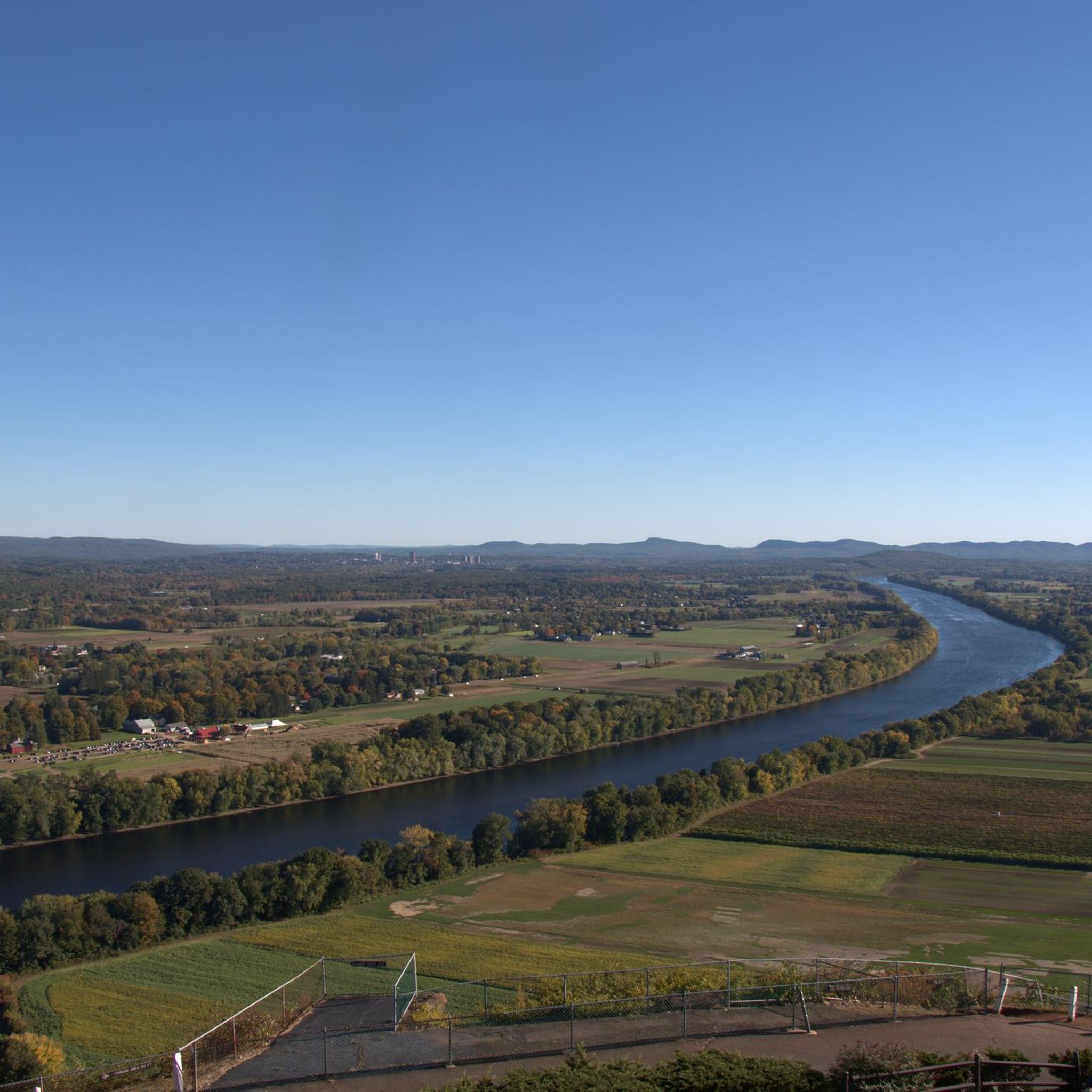
South Sugarloaf Mountain, one of the two summits of Mount Sugarloaf, is a popular tourist spot in the Pocumtuck Range. It offers spectacular views of the Connecticut River, the Pioneer Valley, and the Pelham and Berkshire Hills. The mountain's unique feature is its arkose sandstone cliffs, easily visible from a distance, making it a worthy stop to capture some stunning photos.
0
0

At 791 feet, North Sugarloaf Mountain is the higher of the two summits (South Sugarloaf sits at 652 feet), but it is the less popular of the two peaks. You still get great views of the river valley from the top and can see over to the other summit.
0
0
Mount Toby State Forest is a 755-acre educational forest with miles of hiking trails and expansive viewpoints. Most of the trails are well-kept singletrack trails that have a primitive feel to them.
0
0

Mount Toby is surrounded by an extensive trail system for hikers. Once you reach the summit at 1,269 feet, you can go even higher and climb the fire tower for a fascinating overview of the Connecticut River.
0
0
Frequently Asked Questions
How many hiking trails are there in South Deerfield?
South Deerfield offers a diverse network of over 15 hiking trails, ranging from easy loops to more challenging climbs. These routes traverse the picturesque Connecticut River Valley and the prominent Pocumtuck Range.
What kind of views can I expect on hikes around South Deerfield?
Hikers in South Deerfield can enjoy panoramic vistas of the Connecticut River Valley, the fertile Pioneer Valley, and the distant Pelham and Berkshire Hills. Elevated points like Mount Sugarloaf and the continuous high cliffs of the Pocumtuck Range provide breathtaking scenic overlooks, especially from an observation tower at the summit of South Sugarloaf.
Are there any family-friendly hiking options in South Deerfield?
Yes, South Deerfield has several easy trails suitable for families. For instance, the Hiking loop from Mount Sugarloaf State Reservation is an easy 3.0-mile path exploring the natural features within the state reservation. Another accessible option is the South Sugarloaf Mountain loop from Mount Sugarloaf State Reservation, a 2.5-mile trail that can be completed in about an hour.
Can I bring my dog on the trails in South Deerfield?
Many trails in the South Deerfield area, including those within Mount Sugarloaf State Reservation, are generally dog-friendly. However, it's always recommended to check specific trail regulations or park rules beforehand to ensure pets are permitted and to understand any leash requirements.
What are the best times of year to go hiking in South Deerfield?
The fall season is particularly highlighted for its picturesque and colorful views, making it an excellent time to visit. Spring and summer also offer pleasant hiking conditions, while winter hiking is possible for those prepared for colder weather and potential snow.
Are there any circular hiking routes available?
Yes, South Deerfield features several loop hikes. Popular options include the Mount Toby loop from Montague, a moderate 5.4-mile trail, and the Hiking loop from Mount Sugarloaf State Reservation, an easy 3.0-mile path. The South Sugarloaf Mountain loop from Mount Sugarloaf State Reservation is another popular 2.5-mile circular route.
Where can I find parking for hiking trails in South Deerfield?
Parking is generally available at popular trailheads, especially within Mount Sugarloaf State Reservation. An auto road also leads to the summit of South Sugarloaf, typically open from May through mid-October, where parking is available for those wishing to access the observation tower and picnic areas.
Are there any notable landmarks or attractions to see while hiking?
Absolutely. While hiking, you can explore prominent natural features like South Sugarloaf Mountain and Mount Toby. The region also features the scenic Deerfield River and the Connecticut River Valley. Other nearby attractions include Atkins Reservoir and Puffers Pond.
Are there any waterfall hikes near South Deerfield?
While specific waterfall trails within South Deerfield are not detailed, the broader region boasts over 30 waterfall hiking trails within a 50-mile radius, catering to various skill levels. You may need to explore slightly further afield to find these.
What is the difficulty level of hiking trails in the region?
The hiking trails around South Deerfield offer a range of difficulties. You'll find many easy loops, particularly within Mount Sugarloaf State Reservation, as well as moderate routes with significant elevation gain, such as the Mount Toby loop from Montague. There are no trails classified as difficult in the immediate area.
What do other hikers say about the trails in South Deerfield?
The trails in South Deerfield are highly rated by the komoot community, with an average score of 5.0 stars from 5 reviews. Hikers often praise the varied terrain, the stunning panoramic views from ridgelines, and the well-maintained paths within areas like Mount Sugarloaf State Reservation.
Are there options for longer, more challenging hikes?
For those seeking longer hikes, sections of the Pocumtuck Ridge Trail offer extended exploration. This trail stretches approximately 15 to 20 miles from South Sugarloaf Mountain north to Greenfield, largely following the ridgeline and providing numerous views. A notable part leads to Pocumtuck Rock, a moderate 5.6-mile out-and-back hike.
Is public transport available to reach hiking areas?
Information on direct public transport to specific trailheads in South Deerfield is limited. Most visitors typically rely on personal vehicles to access the hiking areas, especially Mount Sugarloaf State Reservation, where an auto road provides convenient access to the summit during open seasons.
Most popular attractions around South Deerfield

Get inspired with the komoot mobile app


Explore more
Browse the best Hikes in other regions.
