The best running trails around Steinbachtalsperre
4.4
(477)
4,943
runners
541
runs
Jogging around Steinbachtalsperre offers a variety of routes through diverse landscapes. The region is characterized by the reservoir itself, surrounded by woodlands and offering views of the Voreifel landscape. Running routes often follow the reservoir's perimeter or extend into adjacent natural areas, providing a mix of terrain for different preferences. The area provides a range of running trails suitable for various fitness levels.
Best jogging routes around Steinbachtalsperre
- The most popular jogging route is Steinbach Reservoir – Steinbach Reservoir loop from Unteres Steinbachtal, a 7.5 miles (12.0 km) trail that takes 1 hour 17 minutes to complete. This moderate route circles the main reservoir, offering consistent views of the water.
- Another top favourite among local runners is Steinbach Reservoir – Madbachtalsperre loop from Unteres Steinbachtal, a moderate 7.5 miles (12.1 km) path. This route explores the area around the Madbachtalsperre, featuring varied natural scenery.
- Local runners also love the Steinbach Reservoir – View of Cologne loop from Unteres Steinbachtal, a 9.1 miles (14.7 km) trail leading through scenic viewpoints, often completed in about 1 hour 40 minutes.
- Jogging around Steinbachtalsperre is defined by reservoir paths, surrounding woodlands, and open views of the Voreifel landscape. The network offers options for different ability levels, from easier loops to more challenging running routes.
- The routes in Steinbachtalsperre are highly rated by the komoot community with an average score of 4.3 stars from over 400 reviews. More than 4,800 runners have used komoot to explore Steinbachtalsperre's varied terrain.
Last updated: July 8, 2026
3.0
(1)
10
runners
12.0km
01:20
190m
190m
Moderate run. Good fitness required. Mostly paved surfaces. Suitable for all skill levels.
7
runners
13.1km
01:24
150m
150m
Moderate run. Good fitness required. Mostly paved surfaces. Suitable for all skill levels.

Sign up for free
3
runners
15.0km
01:42
230m
230m
Hard run. Very good fitness required. Mostly paved surfaces. Suitable for all skill levels.
5
runners
14.4km
01:32
150m
150m
Moderate run. Good fitness required. Mostly paved surfaces. Suitable for all skill levels.
11
runners
16.8km
01:51
250m
250m
Hard run. Very good fitness required. Mostly paved surfaces. Suitable for all skill levels.
Get access to more routes and recommendations from other explorers.
Sign up for free
Already have an account?
Our route recommendations are based on thousands of hikes, rides, and runs completed by other people on komoot.
Start today with a free account
Your next adventure awaits.
Login or Signup

Tips from the Community

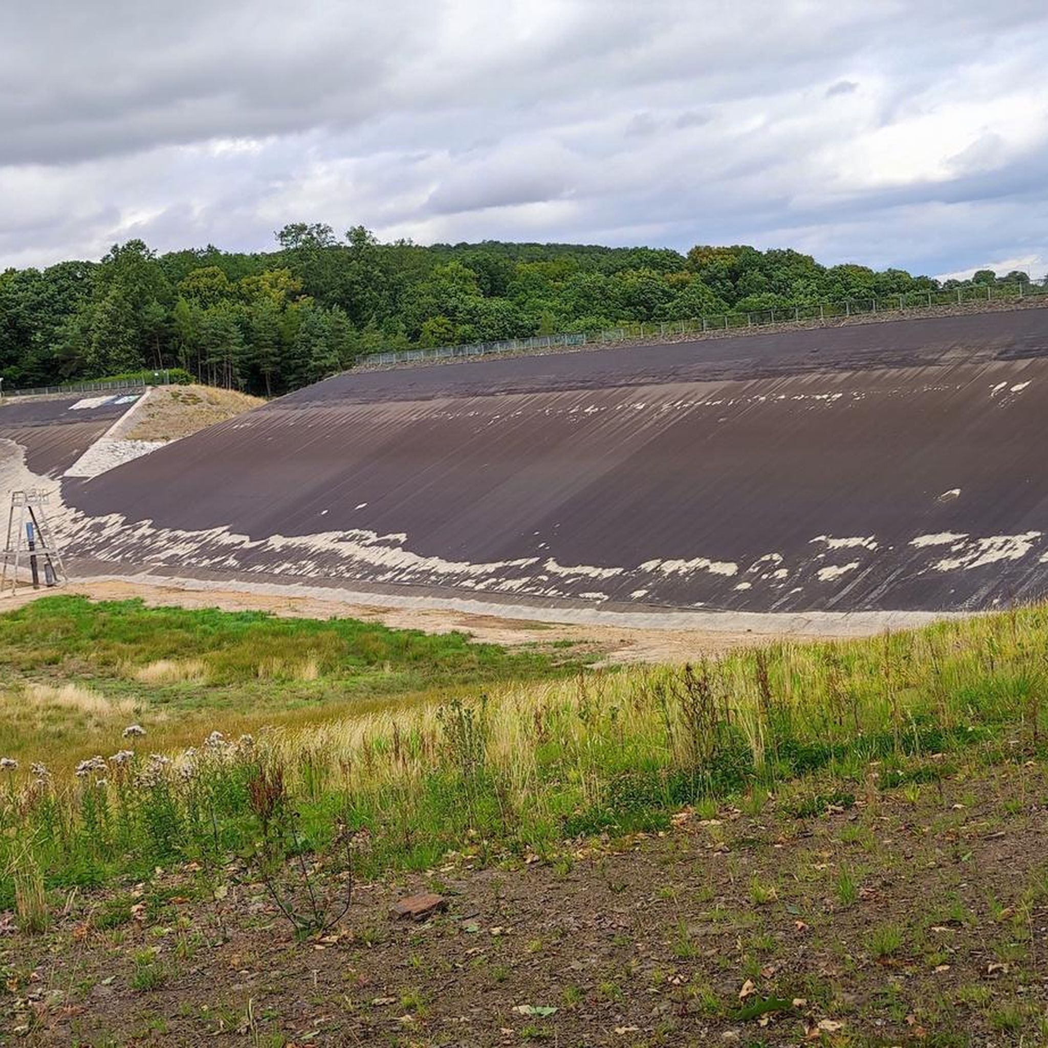
The nearby Steinbach reservoir is now - that is, after the heavy rain catastrophe of July 2021 - dry, and instead of water, a green area can be seen. Here at the Madbach reservoir, in comparison practically the little brother, the reservoir can indeed still be found.
4
0

I find the information boards about the different tree species very helpful.
1
0
You can also take a break in front of an empty reservoir that has been cleared of undergrowth and vegetation. 😉
0
0

It's really beautiful, unfortunately a construction site: no water, no complete circuit because of dam work
0
0

There are many boards with useful information about trees and animals on the dam path. Not only educational for children...
1
0

If you remember the Steinbach Dam before 2021, it now unfortunately offers a depressing sight... 😟
2
0
A wonderful resting place! 😎 However, the view has unfortunately worsened since the flood in 2021...
0
0

After the flood disaster, an overflow edge was installed in the dam. The Steinbach Dam has been empty since the flood of July 14, 2021.
0
1
Frequently Asked Questions
How many running routes are available around Steinbachtalsperre?
The Steinbachtalsperre area offers a wide variety of running options, with nearly 500 routes recorded on komoot. This includes 69 easy routes, over 360 moderate trails, and 57 more challenging paths for experienced runners.
Are there any easy or beginner-friendly running trails in the region?
Yes, the Steinbachtalsperre region has 69 easy running routes suitable for beginners or those looking for a more relaxed jog. These trails often feature gentler gradients and well-maintained surfaces, allowing for an enjoyable experience without excessive challenge.
What kind of terrain can I expect on the jogging routes around Steinbachtalsperre?
The running routes around Steinbachtalsperre offer diverse terrain. You'll find paths that follow the reservoir's perimeter, winding through surrounding woodlands, and opening up to views of the Voreifel landscape. This mix provides options for different preferences, from flat sections to gentle inclines.
Are there any circular running paths around Steinbachtalsperre?
Yes, many of the running routes in the area are circular, allowing you to start and finish at the same point. For example, the Steinbach Reservoir – Erft Cycle Path loop from Unteres Steinbachtal is a moderate 11.9 km (7.4 miles) route that offers a scenic circular experience.
What do other runners enjoy most about the trails in Steinbachtalsperre?
The running trails in Steinbachtalsperre are highly rated by the komoot community, with an average score of 4.3 stars from over 400 reviews. Runners frequently praise the varied natural scenery, the well-maintained paths, and the consistent views of the reservoir and the Voreifel landscape.
Are there any longer, more challenging running routes for experienced athletes?
For those seeking a greater challenge, the region offers 57 difficult running routes. An example is the Jägersruh Shelter loop from Arloff, a demanding 16.5 km (10.3 miles) trail with significant elevation changes, perfect for a longer, more intense run.
What are some interesting sights or landmarks I can see while running?
While jogging, you can enjoy various points of interest. The Steinbach Reservoir itself is a prominent feature. You might also discover a quiet spot with a great view or pass by the Picnic Shelter at Steinbachtalsperre. For a unique perspective, look for the View of the empty Steinbach Reservoir.
Are there any places to stop for refreshments or a break along the running routes?
Yes, you can find options for a break. The Waldgasthaus Steinbach Brewery & Beer Garden is a notable spot where you can pause and refresh yourself after your run, offering a pleasant atmosphere near the trails.
Is the Steinbachtalsperre area suitable for running with dogs?
Many trails around Steinbachtalsperre are dog-friendly, offering open spaces and natural paths for you and your canine companion to enjoy. However, it's always recommended to keep dogs on a leash, especially in nature protection areas or near wildlife, and to check specific route regulations beforehand.
What is the typical length and duration of a running route in this area?
Running routes around Steinbachtalsperre vary significantly in length and duration. Moderate trails often range from 9 to 15 kilometers (5.5 to 9.3 miles), taking approximately 1 to 2 hours to complete, depending on your pace and the specific route's elevation profile.
Are there good parking options for accessing the running trails?
Yes, there are generally good parking facilities available near popular access points for the running trails around Steinbachtalsperre. Many routes, such as those starting from Unteres Steinbachtal, have designated parking areas to accommodate visitors.
Can I reach the running trails around Steinbachtalsperre using public transport?
While specific public transport connections can vary, the Steinbachtalsperre area is generally accessible. It's advisable to check local bus schedules and routes that serve the towns and villages surrounding the reservoir, as some may have stops within walking distance of trailheads.
Most popular routes around Steinbachtalsperre
Most popular attractions around Steinbachtalsperre

Get inspired with the komoot mobile app


Explore more
Browse the best Running Trails & Routes in other regions.
