The best walks and hikes in Helena-Lewis And Clark National Forest
4.7
(14)
185
hikers
15
hikes
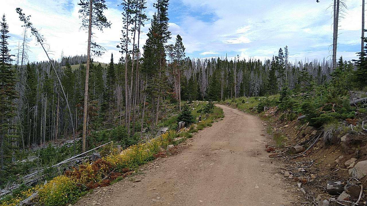
Hiking in Helena-Lewis And Clark National Forest offers access to nearly 2.9 million acres of diverse landscapes across central and north-central Montana. The region features island mountain ranges, alpine peaks, and dramatic rocky cliffs, including significant portions of the Continental Divide. This vast forest encompasses pristine wilderness areas and numerous rivers and lakes, providing varied terrain for outdoor activities.
Best hiking trails in Helena-Lewis And Clark National Forest
- The most popular hiking route is Mt. Ascension via Lower DeFord and Aftershock Trail, a 6.4 miles (10.3 km) trail that takes about 3 hours 6 minutes to complete. This moderate route features a steady ascent.
- Another top favourite among local hikers is Heart Lake via Mainline Trail (#481), a moderate 4.7 miles (7.5 km) path. This route leads to a scenic lake, typically completed in about 2 hours 12 minutes.
- Local hikers also love the Rodney Ridge Loop, a 2.6 miles (4.1 km) trail leading through varied terrain, often completed in about 1 hour 14 minutes.
- Hiking in Helena-Lewis And Clark National Forest is defined by island mountain ranges, alpine peaks, and rocky cliffs, with an extensive network of trails. The network offers options for different ability levels, from easy day hikes to challenging multi-day backpacking adventures.
- The routes in Helena-Lewis And Clark National Forest are highly rated by the komoot community with an average score of 4.4 stars from over 15 reviews. More than 130 hikers have used komoot to explore Helena-Lewis And Clark National Forest's varied terrain.
Last updated: October 11, 2026
7
hikers
10.3km
03:05
340m
300m
The Mt. Ascension via Lower DeFord and Aftershock Trail offers a delightful blend of wide, easy paths and engaging singletrack through Helena's Mount Ascension City Park. You'll start on a gentle gravel path, then climb through fragrant ponderosa pine forests, eventually reaching high meadows that open up to spectacular views of the Helena Valley. It's a moderate 6.4-mile (10.3 km) hike with 1107 feet (337 metres) of elevation gain, taking about 3 hours and 5 minutes, perfect for experiencing varied terrain and scenic overlooks.
To plan your visit, head to the DeFord Trailhead, which provides ample parking and essential amenities like pet waste bags. This trail is popular with hikers, mountain bikers, and trail runners, so expect company, especially on weekends. Dogs are welcome but must be leashed. For the best experience, including vibrant wildflowers, aim to hike between May and June.
This route is a fantastic example of the extensive Mount Ascension trail system, offering a moderate option within a network of over 30 trails. The Aftershock Trail, in particular, connects to various other paths, allowing for numerous loop options and alternative ways to reach the summit. It's a great way to explore the South Hills of Helena, known for its diverse flora and fauna, including birds and butterflies.
2
hikers
4.13km
01:14
130m
130m
The Rodney Ridge Loop offers a dynamic hiking experience right outside Helena, Montana. You'll ascend through open pine forests, then emerge onto a rocky ridgeline that provides sweeping panoramic views of the city and the Elkhorn Mountains. The route then dips back into shaded forest, offering a pleasant mix of sun and shade, with sunny meadows and shady ravines along the way. Look for abundant wildflowers in late spring and common wildlife sightings.
This easy 2.6-mile (4.1 km) loop involves 429 feet (131 metres) of elevation gain and typically takes about 1 hour and 13 minutes to complete. The trail is easily accessible from the Rodney Ridge Trailhead in Helena and is a popular shared-use path for hikers, runners, and mountain bikers. It's a great option for a relatively quick outing with a high reward in terms of scenery.
Rodney Ridge is part of the larger Helena South Hills trail system, providing options for longer adventures if you wish to extend your hike. The area is particularly known for its diverse ecosystems, supporting a variety of wildflowers, butterflies, and birdlife, making it a fantastic spot for nature observation during the warmer months.

3
hikers
7.54km
02:13
300m
50m
Embark on a moderate hike along the Heart Lake via Mainline Trail (#481), a 4.7-mile (7.5 km) route that takes about 2 hours and 12 minutes to complete. You'll gain 989 feet (301 metres) in elevation as you wind through young pine and aspen forests. Early on, the trail offers lush sections with side-streams and a pretty cascade, providing a refreshing start. The path gradually ascends, with the final mile becoming steeper as you approach the stunning Heart Lake. This glacial lake is dramatically set against cliffs that often retain pockets of snow, creating a picturesque backdrop for your efforts.
Before you set out, know that this trail is shared by both hikers and horses, so be prepared to encounter equestrian users along the way. Heart Lake itself is a popular destination, especially for those interested in fishing or backpacking. If you are considering an overnight adventure, established campsites are available near the lake. Plan your visit to allow ample time to enjoy the serene environment and the views from the lake.
This route is nestled within Montana's Helena National Forest, offering a true immersion into the region's natural beauty. The presence of a glacial lake, carved into the landscape and framed by dramatic cliffs, highlights the unique geological features of this area. It's a notable trail for its accessibility to a pristine alpine environment, making it a favored spot for both day-trippers and those seeking a longer wilderness experience.
8.86km
03:25
1,020m
0m
The Casey Peak Trail offers a truly rewarding, albeit challenging, journey through the North Elkhorns. You'll traverse beautiful forests along the East Fork of McClellan Creek before the terrain steepens dramatically, leading you through areas impacted by the 1988 Warm Springs Fire. The highlight is undoubtedly the summit of Casey Peak, where you'll find a curious old fire lookout structure and be greeted by sweeping vistas of Helena, Canyon Ferry Lake, and the Continental Divide. This route is a fantastic choice for those who appreciate a strenuous climb with a big payoff.
Planning your visit to Casey Peak Trail means preparing for a demanding hike. The trail is rated difficult, covering 5.5 miles (8.9 km) with a significant 3345 feet (1020 metres) of elevation gain, typically taking around 3 hours and 24 minutes. Access is via the Casey Meadows Trailhead, and while dogs are welcome, ensure they are fit for the steep, rocky sections. An early start is advisable, especially on warmer days, to enjoy the cooler temperatures and clear views.
Beyond the physical challenge, Casey Peak is notable for its historical fire lookout remnants and its popularity as a conditioning hike for serious outdoor enthusiasts. In winter, it transforms into a popular snowshoeing destination, offering a different perspective of the landscape and potentially a frozen waterfall. The trail's demanding nature and the extensive views from Casey Peak make it a standout option for experienced hikers in the Jefferson County area of Montana.
7.84km
02:59
740m
200m
If you're seeking a challenging hike with immense payoffs, the Vigilante Overlook Trail (Hanging Valley) delivers. This moderate 4.9-mile (7.8 km) route, with its 2432 feet (741 metres) of elevation gain, takes you through a dramatic landscape of steep canyon-sides and coniferous forests. You'll navigate numerous switchbacks and even descend ladders in sections, all leading to breathtaking panoramic views into Trout Creek Canyon and unique limestone formations.
Plan for a roughly 2-hour and 59-minute adventure, starting at the Vigilante Campground. This trailhead, found at the end of Trout Creek Road about 24 miles northeast of Helena, offers parking, vault toilets, and drinking water. It's a strenuous ascent, so make sure you're well-prepared and consider avoiding it as your very first hike of the season.
This trail, also known as National Recreation Trail #247, is renowned for its geological wonders within the Big Belt Mountains. You'll encounter towering limestone cliffs, a natural bridge, and a narrow "hole in the wall" viewpoint. The lower sections of the valley are surprisingly moist, supporting diverse vegetation, including lichen, adding to the unique character of this rewarding Montana hike.
Get access to more routes and recommendations from other explorers.
Already have an account?
Our route recommendations are based on thousands of hikes, rides, and runs completed by other people on komoot.
Start today with a free account
Your next adventure awaits.
Popular around Helena-Lewis And Clark National Forest

Frequently Asked Questions
How many hiking trails are available in Helena-Lewis And Clark National Forest?
Helena-Lewis And Clark National Forest offers a wide variety of hiking experiences with over 25 distinct routes. These range from easy strolls to challenging multi-day backpacking adventures, catering to all skill levels.
What types of terrain can I expect to find on the trails?
The forest's topography is incredibly diverse, featuring island mountain ranges, alpine peaks, and dramatic rocky cliffs. You'll encounter everything from river-side paths and limestone canyons to high-elevation trails along the Continental Divide and through pristine wilderness areas.
Are there any easy or family-friendly hiking options?
Yes, there are several easy and family-friendly trails. For instance, the River's Edge Trail via Giant Springs State Park is an easy path following the Missouri River. The Crow Creek Falls Trail is another family-friendly option leading through a limestone canyon, and the Trout Creek Canyon Trail is known for its easy access and towering rock formations.
Where can I find challenging hikes or multi-day backpacking routes?
For challenging hikes and backpacking, consider routes that traverse the Continental Divide, such as the From Benchmark to South Fork Loop. The Bob Marshall Wilderness and Scapegoat Wilderness also offer extensive, unspoiled environments for multi-day adventures. The Stemple Pass Loop is another difficult route with significant elevation gain.
Are there any trails with waterfalls in the forest?
Absolutely! The forest is home to several beautiful waterfalls. Memorial Falls is an accessible option, while the Crow Creek Falls Trail leads to a scenic waterfall. Additionally, the Our Lake Trail features two waterfalls on its way to Our Lake.
What notable landmarks or natural features can I see while hiking?
Hikers can explore a wealth of natural and historical landmarks. Significant portions of the Continental Divide National Scenic Trail run through the forest, offering spectacular views. The Chinese Wall in the Bob Marshall Wilderness is a geological marvel, a 13-mile long, 1,000-foot-high limestone cliff. You can also visit the historic Gates of the Mountains Wilderness, or explore the trails of Bob Marshall Wilderness.
Are there any loop trails available for hikers?
Yes, the forest offers several loop trails. A notable example is the Stemple Pass Loop, which provides a challenging circular route. Another option is the From Benchmark to South Fork Loop, part of the Continental Divide Trail, offering a moderate circular experience.
What do other hikers enjoy most about the trails in Helena-Lewis And Clark National Forest?
The trails in Helena-Lewis And Clark National Forest are highly rated by the komoot community, with an average score of 4.7 stars. Hikers frequently praise the diverse landscapes, from river views to alpine scenery, and the opportunity to experience pristine wilderness. The historical significance, particularly related to the Lewis and Clark Expedition, is also a highlight for many.
When is the best time of year to go hiking in this region?
The best time for hiking generally depends on the elevation and specific trail. Late spring through early fall (May to October) typically offers the most favorable conditions, with snowmelt usually complete on lower elevation trails by late spring. Higher elevation routes, especially along the Continental Divide, may retain snow later into the summer.
Are dogs allowed on the hiking trails?
Many trails within the Helena-Lewis And Clark National Forest are dog-friendly, but regulations can vary, especially in designated wilderness areas or near wildlife habitats. It's always best to check specific trail rules and ensure your dog is on a leash and you practice Leave No Trace principles.
Are there any trails that follow the historic Lewis and Clark Expedition routes?
Yes, the forest is rich in history and preserves segments of the routes traversed by the Lewis and Clark Expedition between 1804 and 1806. Hiking here allows visitors to experience landscapes much as the explorers did, particularly in areas like the Gates of the Mountains Wilderness and along the Continental Divide.
What kind of wildlife might I encounter on the trails?
The Helena-Lewis And Clark National Forest is home to diverse wildlife, including deer, elk, moose, black bears, and occasionally grizzly bears in more remote areas. Birdwatchers can spot various species. Always be aware of your surroundings, carry bear spray, and know how to react to wildlife encounters.
Most popular routes in Helena-Lewis And Clark National Forest
Most popular attractions in Helena-Lewis And Clark National Forest

Get inspired with the komoot mobile app


Explore more
Browse the best Hikes in other regions.
