The best running trails around Creissels
4.4
(59)
6,531
runners
20
runs
Jogging routes around Creissels traverse a diverse landscape, characterized by the dramatic topography of the Causse du Larzac and the Tarn Valley. Runners encounter varied terrain, from challenging ascents on limestone cliffs to playful descents, often with panoramic views over the Millau Viaduct. The region's natural features include the Creissels Waterfalls and extensive trail networks, providing a stimulating environment for running. These paths offer a mix of forest floors, rocky sections, and open landscapes.
Best jogging routes around Creissels
- The…
Last updated: October 10, 2026
53
runners
11.9km
01:35
440m
440m
Hard run. Very good fitness required. Mostly paved surfaces. Suitable for all skill levels.
3.5
(2)
30
runners
Hard run. Very good fitness required. Mostly paved surfaces. Suitable for all skill levels.

4.8
(6)
157
runners
6.91km
00:44
60m
60m
Moderate run. Good fitness required. Mostly paved surfaces. Suitable for all skill levels.
112
runners
9.25km
01:20
430m
430m
Hard run. Very good fitness required. Mostly paved surfaces. Suitable for all skill levels.
32
runners
9.25km
01:17
380m
380m
Hard run. Very good fitness required. Mostly paved surfaces. Suitable for all skill levels.
Get access to more routes and recommendations from other explorers.
Already have an account?
Our route recommendations are based on thousands of hikes, rides, and runs completed by other people on komoot.
Start today with a free account
Your next adventure awaits.

Tips from the Community

Built between 1818 and 1821, the Lerouge bridge became one of the main structures for crossing the Tarn in Millau. It replaced the Pont Vieux, several arches of which had been destroyed by a flood in 1758, leaving the town without a permanent bridge for over sixty years. During this long period, crossing the Tarn was mainly done by ferry. The project was launched on the initiative of the prefect of Aveyron, d’Estourmel. The plans were drawn up by Pierre-Jacques Le Rouge, an engineer for the district. The first stone was laid on June 20, 1818, and the bridge was opened to traffic in January 1821. Its name therefore comes from its designer, not from the color of its stones. A curious detail: its construction was largely financed by private individuals, and a toll was collected until 1875. This tax even caused tensions with the inhabitants of Creissels, some of whom continued to cross the Tarn on foot or by boat to avoid paying it.
3
0
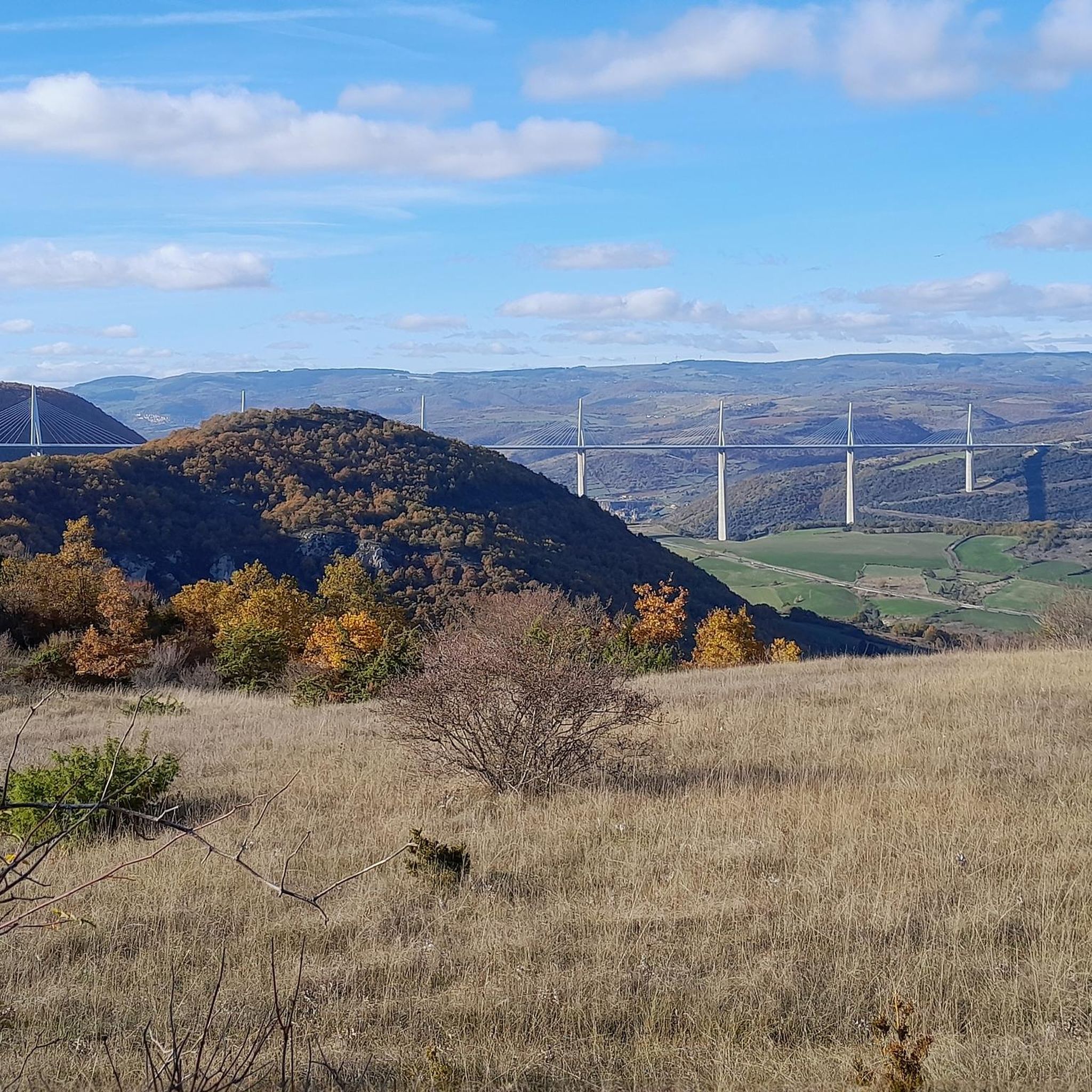
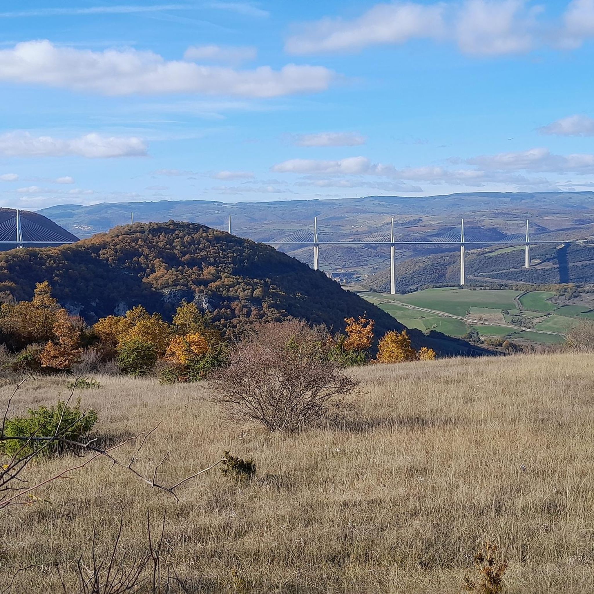
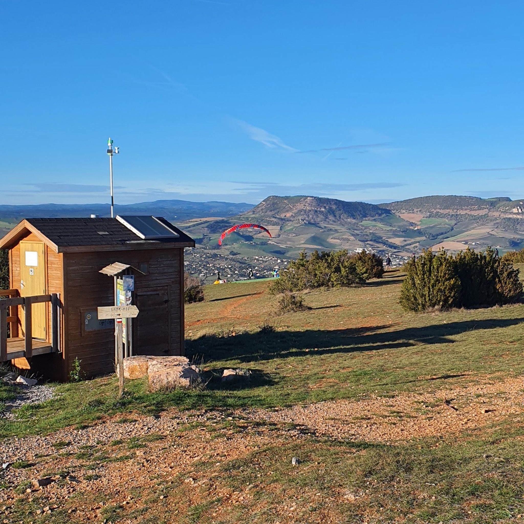
From the Larzac plateau, the Brunas site offers a vast panorama of the Millau valley. Stretched between the two banks of the Tarn, the viaduct with its seven concrete piers appears in its entirety. Behind it unfolds the entire causse Rouge, a large limestone plateau whose undulations dominate the valley. Then, the Puech d’Andan is distinguished by its wooded silhouette, cut in two by a clear central notch. Further to the right stands the Pouncho d'Agast, a pyramidal promontory marking the beginning of the causse Noir at an altitude of 841 m. Brunas is also a true site for free flight. The take-off area is located directly on the plateau; the site is mainly used with a north wind and allows paragliders to take off and then land in the vicinity of the same sector, with approximately 370 m of elevation difference down to the valley. The spectacle of the sails evolving in front of the viaduct adds a particular dimension to this panorama.
2
0
From the Larzac plateau, the Brunas site offers a vast panorama of the Millau valley. Stretched between the two banks of the Tarn, the viaduct with its seven concrete piers appears in its entirety. Behind it unfolds the entire Causse Rouge, a large limestone plateau whose undulations dominate the valley. Then, the Puech d’Andan is distinguished by its wooded silhouette, cut in two by a clear central notch. Further to the right stands the Pouncho d'Agast, a pyramidal promontory marking the beginning of the Causse Noir at an altitude of 841 m. Brunas is also a real site for paragliding. The take-off area is located directly on the plateau; the site is mainly used with a north wind and allows paragliders to take off and land near the same area, with an altitude difference of about 370 m to the valley. The spectacle of the sails evolving in front of the viaduct adds a special dimension to this panorama.
3
0
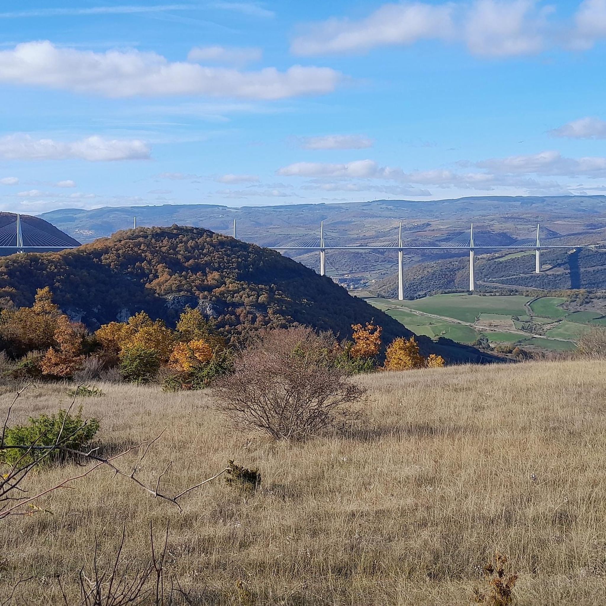
Perched at an altitude of about 730 meters, the Cap de Coste viewpoint overlooks the eastern end of the Boundoulaou cirque. It reveals a vast panorama of the Millau basin and its surrounding massifs. To the left, the easily recognizable Millau Viaduct spans the Tarn valley to connect the Larzac to the Causse Rouge. Further to the right stretches the latter: a large limestone plateau whose undulations dominate the valley. Then, the Puech d’Andan stands out with its wooded silhouette, cut in two by a clear central notch. Finally, further away, the Pouncho d’Agast, an emblematic relief of the Causse Noir, is easily recognized by its profile like a true limestone pyramid.
3
0
Perché at an altitude of approximately 730 meters, the Cap de Coste viewpoint overlooks the eastern end of the Boundoulaou cirque. It reveals a vast panorama of the Millau basin and its surrounding massifs. To the left, the easily recognizable Millau Viaduct spans the Tarn valley, connecting the Larzac to the Causse Rouge. Further to the right stretches the latter: a large limestone plateau whose undulations dominate the valley. Then, the Puech d’Andan stands out with its wooded silhouette, cut in two by a clear central notch. Finally, further away, the Pouncho d’Agast, an emblematic relief of the Causse Noir, is easily recognized by its profile like a true limestone pyramid.
2
0
La Maladrerie is located on the left bank of the Tarn, a few minutes' walk from the center of Millau. This former establishment, intended to accommodate lepers, has today become a vast space for sports, leisure, and relaxation. Around the football and rugby fields, a playground, a fitness area, and above all a leisure base on the banks of the Tarn extend. The Saoutadou leisure island offers a shaded area conducive to breaks and picnics, while the Parc Aquavagues allows for kayaking, rafting, hydrospeed, and other whitewater activities.
2
0


The Pas Destrech Cross, which the biker encounters here at the top, is a truly remarkable small sacred monument. Approaching it from behind, it appears to be made of black metal, but then you realize that this is only the basic framework for the wooden beams of the actual cross. Its shape is also rather unusual for a summit cross: the longitudinal and transverse beams, which are of equal length, are each provided with another short beam at the end, giving the viewer the impression of a square floor plan.
1
0
Frequently Asked Questions
How many running routes are available around Creissels?
Creissels offers a diverse network of over 18 jogging routes, catering to various fitness levels. These include a mix of moderate and challenging paths through the region's stunning landscapes.
What kind of terrain can I expect on the jogging routes in Creissels?
The running routes in Creissels feature highly varied terrain, from challenging ascents on limestone cliffs to playful descents. You'll encounter forest floors, rocky sections, and open landscapes, especially along the dramatic topography of the Causse du Larzac and the Tarn Valley.
Are there any easy or moderate running routes for beginners in Creissels?
While many routes in Creissels are considered difficult, there are 11 moderate jogging routes available. For example, the Maladrerie loop from Millau is a moderate 6.7 km path, offering a less strenuous option for those new to trail running in the area.
Can I find routes with panoramic viewpoints in Creissels?
Absolutely! Many running routes in Creissels offer breathtaking panoramic views. Trails along the Larzac cornices, such as the Larzac Corniches Trail, provide impressive vistas over Millau and the surrounding areas. The Cap de Coste Viewpoint is another notable spot for incredible scenery.
Are there any natural attractions, like waterfalls, to see while running near Creissels?
Yes, a significant natural highlight is the Cascade de Creissels (Creissels Waterfalls), a 23-meter high waterfall formed as water cascades from the Larzac plateau. While not directly on a main jogging route listed, the area around the waterfall is a nature preserve with paths, and the Cascade des Raspes du Tarn is another beautiful waterfall nearby.
Are the running trails around Creissels suitable for families?
Creissels offers a variety of trails, and while some are challenging, there are moderate options that could be suitable for active families. It's best to check the difficulty grade and distance of specific routes, such as the moderate Maladrerie loop from Millau, to ensure they match your family's fitness level.
Are there circular running routes available in Creissels?
Yes, many of the running routes around Creissels are circular. Popular examples include the Larzac Corniches Trail, the extensive Creissels / Le Larzac - Trail N04 loop, and the Millau Corniche – Downhill "chemin du facteur" loop, all designed as loops for convenient exploration.
What are the parking options for accessing running trails in Creissels?
While specific parking locations for each trail are not detailed here, Creissels is well-known for its accessibility to outdoor activities. Many trailheads, especially those starting directly from Creissels or nearby Millau, typically have designated parking areas. It's advisable to check local signage upon arrival.
Is public transport available to reach the jogging paths around Creissels?
Creissels is a smaller community, and while local bus services might connect to nearby towns like Millau, direct public transport to specific trailheads might be limited. For the most flexibility, driving to the starting points of the running routes is often recommended.
What do other runners say about their experience in Creissels?
The running routes in Creissels are highly rated by the komoot community, with an average score of 4.4 stars from over 40 reviews. Runners often praise the dramatic scenery, varied terrain, and the challenging yet rewarding nature of the trails, especially those offering views of the Millau Viaduct.
What is the best time of year to go running in Creissels?
Creissels offers a stimulating environment for runners year-round. While spring and autumn provide pleasant temperatures and vibrant landscapes, summer can be warm, making early morning or late afternoon runs ideal. In winter, the area around the Cascade de Creissels can even transform into a 'magical spectacle' of ice concretions, offering a unique experience for those prepared for colder conditions.
Are there any iconic landmarks visible from the running routes in Creissels?
Yes, the iconic Millau Viaduct is a prominent feature of the landscape, and many trails, particularly those along the Larzac cornices, offer stunning perspectives of this architectural marvel. The Pas Destrech Cross on the Causse du Larzac also provides incredible panoramic views over Millau and the viaduct.
How challenging are the running routes in Creissels generally?
The running routes in Creissels are known for their varied difficulty. While there are moderate options, a significant number of trails are classified as difficult, featuring considerable elevation gains and technical sections. These routes are particularly popular with experienced trail runners seeking a challenge.
Are there any cafes or places to refresh near the running trails in Creissels?
Creissels and the nearby town of Millau offer various amenities, including cafes and restaurants, where you can refresh after your run. While specific establishments directly adjacent to trailheads are not listed, you'll find options within the villages to refuel and relax.
Can I bring my dog on the running trails in Creissels?
The natural areas around Creissels, including the Natura 2000 network and ZNIEFF zones, are generally welcoming to dogs, especially on designated trails. However, it's always recommended to keep your dog on a leash, respect local wildlife, and adhere to any specific signage regarding pet regulations on individual routes or protected areas.
Most popular attractions around Creissels

Get inspired with the komoot mobile app


Explore more
Browse the best Running Trails & Routes in other regions.
